Aubenas night lights from space
Night Light of Aubenas (Auvergne-Rhône-Alpes) from space (France) Src. Average luminocity for 10x10km area is 24.7636% and for 50x50km: 3.4797%.
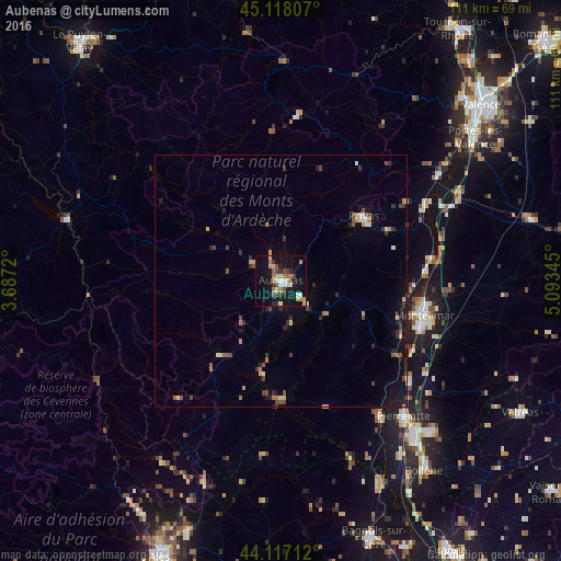
Analysis of Aubenas night lights 2016
Square area 10x10 km:
 0.76%
0.76%90-99
5%80-89
3.18%70-79
2.88%60-69
5.45%50-59
1.52%40-49
5%30-39
2.88%20-29
3.94%10-19
28.18%0-9
41.21%Square area 50x50 km:
0.08%90-99
0.48%80-89
0.32%70-79
0.46%60-69
0.58%50-59
0.32%40-49
0.8%30-39
0.55%20-29
0.76%10-19
2.45%0-9
93.2%Clear (daylight) street map image can be seen on geolist.org.
Map coordinates:
45° 7' 5.1" North, 3° 41' 13.9" East
44° 37' 11.1" North, 4° 23' 25.2" East
44° 7' 1.6" North, 5° 5' 36.4" East
Some cities around Aubenas sort by population:
• Montélimar
29.7 km =18.5 mi,  104°
104°
• Pierrelatte
36.8 km =22.9 mi,  137°
137°
• Privas
20.9 km =13 mi,  52°
52°
• Le Teil
24.6 km =15.3 mi,  109°
109°
• Livron-sur-Drôme
39.7 km =24.7 mi,  63°
63°
• Bourg-Saint-Andéol
34 km =21.1 mi, 143°
• Loriol-sur-Drôme
36.6 km =22.7 mi,  67°
67°
• La Voulte-sur-Rhône
36.7 km =22.8 mi, 56°
3036418 (p: 13,134)
Sources (retrieved 2019-11-25):
» Earth at Night: Flat Maps 2012, 2016