Portes-lès-Valence night lights from space
Night Light of Portes-lès-Valence (Auvergne-Rhône-Alpes) from space (France) Src. Average luminocity for 10x10km area is 45.4063% and for 50x50km: 11.161%.
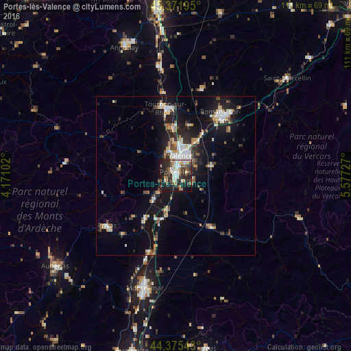
Analysis of Portes-lès-Valence night lights 2016
Square area 10x10 km:
 7.46%
7.46%90-99
10.79%80-89
4.13%70-79
1.75%60-69
8.41%50-59
4.76%40-49
7.46%30-39
8.41%20-29
19.84%10-19
25.56%0-9
1.43%Square area 50x50 km:
1.49%90-99
2.2%80-89
0.96%70-79
1.14%60-69
1.25%50-59
1.23%40-49
1.59%30-39
1.43%20-29
3.14%10-19
9.67%0-9
75.91%Clear (daylight) street map image can be seen on geolist.org.
Map coordinates:
45° 22' 19" North, 4° 10' 15.7" East
44° 52' 33.1" North, 4° 52' 26.9" East
44° 22' 31.5" North, 5° 34' 38.2" East
Some cities around Portes-lès-Valence sort by population:
• Valence
6.2 km =3.9 mi,  26°
26°
• Bourg-lès-Valence
8.1 km =5 mi,  11°
11°
• Guilherand-Granges
6.3 km =3.9 mi,  359°
359°
• Livron-sur-Drôme
11.3 km =7 mi,  193°
193°
• Saint-Péray
8.4 km =5.2 mi,  344°
344°
• Chabeuil
11.3 km =7 mi,  77°
77°
• Loriol-sur-Drôme
15 km =9.3 mi,  197°
197°
• La Voulte-sur-Rhône
11.3 km =7 mi,  221°
221°
2985987 (p: 8,675)
Sources (retrieved 2019-11-25):
» Earth at Night: Flat Maps 2012, 2016