Guilherand-Granges night lights from space
Night Light of Guilherand-Granges (Auvergne-Rhône-Alpes) from space (France) Src. Average luminocity for 10x10km area is 64.5746% and for 50x50km: 11.1599%.
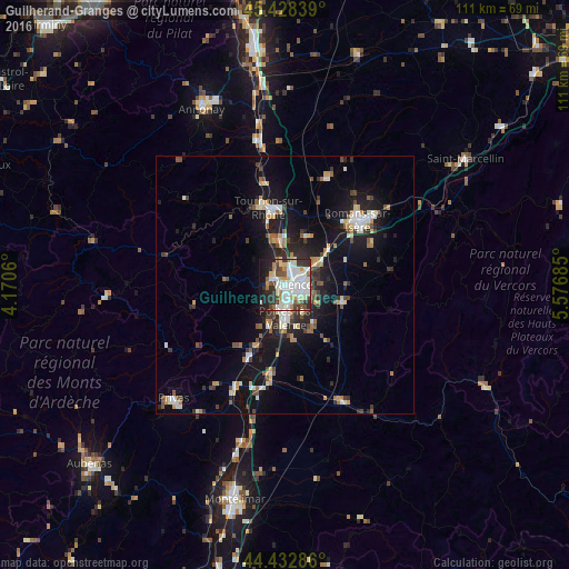
Analysis of Guilherand-Granges night lights 2016
Square area 10x10 km:
 18.73%
90-99
21.9%80-89
7.14%70-79
3.65%60-69
4.29%50-59
5.4%40-49
6.67%30-39
8.1%20-29
10.95%10-19
12.54%0-9
0.63%Square area 50x50 km:
1.48%90-99
2.26%80-89
0.97%70-79
1.09%60-69
1.19%50-59
1.23%40-49
1.61%30-39
1.42%20-29
3.16%10-19
9.75%0-9
75.84%Clear (daylight) street map image can be seen on geolist.org.
Map coordinates:
45° 25' 42.2" North, 4° 10' 14.2" East
44° 55' 58" North, 4° 52' 25.4" East
44° 25' 58.3" North, 5° 34' 36.7" East
Some cities around Guilherand-Granges sort by population:
• Valence
2.9 km =1.8 mi,  105°
105°
• Bourg-lès-Valence
2.3 km =1.4 mi,  46°
46°
• Tournon-sur-Rhône
15.2 km =9.4 mi,  347°
347°
• Portes-lès-Valence
6.3 km =3.9 mi,  179°
179°
• Saint-Péray
2.9 km =1.8 mi,  308°
308°
• Chabeuil
11.7 km =7.3 mi, 109°
• Tain-l’Hermitage
15 km =9.3 mi, 354°
• La Voulte-sur-Rhône
16.6 km =10.3 mi,  206°
206°
3014277 (p: 11,365)
Sources (retrieved 2019-11-25):
» Earth at Night: Flat Maps 2012, 2016