Le Trait night lights from space
Night Light of Le Trait (Normandy) from space (France) Src. Average luminocity for 10x10km area is 12.7283% and for 50x50km: 15.7153%.
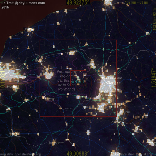
Analysis of Le Trait night lights 2016
Square area 10x10 km:
 0.56%
0.56%90-99
2.1%80-89
1.26%70-79
1.68%60-69
1.68%50-59
1.82%40-49
3.36%30-39
2.1%20-29
1.12%10-19
0.56%0-9
83.75%Square area 50x50 km:
3.76%90-99
3.11%80-89
1.15%70-79
1.2%60-69
1.45%50-59
1.86%40-49
2.22%30-39
2.78%20-29
3.82%10-19
7.91%0-9
70.74%Clear (daylight) street map image can be seen on geolist.org.
Map coordinates:
49° 55' 25.5" North, 0° 6' 47.6" East
49° 28' 8.2" North, 0° 48' 58.8" East
49° 0' 35.6" North, 1° 31' 10.1" East
Some cities around Le Trait sort by population:
• Canteleu
15.4 km =9.6 mi,  101°
101°
• Barentin
13.1 km =8.1 mi,  49°
49°
• Maromme
15 km =9.3 mi,  85°
85°
• Yvetot
17 km =10.6 mi,  345°
345°
• Déville-lès-Rouen
17 km =10.6 mi, 89°
• Petit-Couronne
17.3 km =10.7 mi,  123°
123°
• Notre-Dame-de-Bondeville
17 km =10.6 mi,  84°
84°
• Pavilly
14.8 km =9.2 mi,  42°
42°
2999126 (p: 5,506)
Sources (retrieved 2019-11-25):
» Earth at Night: Flat Maps 2012, 2016