Pierrelatte night lights from space
Night Light of Pierrelatte (Auvergne-Rhône-Alpes) from space (France) Src. Average luminocity for 10x10km area is 37.9397% and for 50x50km: 10.3334%.
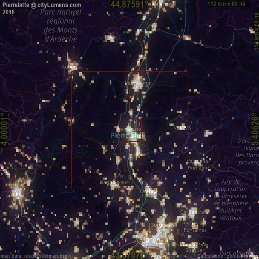
Analysis of Pierrelatte night lights 2016
Square area 10x10 km:
 7.14%
7.14%90-99
8.1%80-89
3.49%70-79
4.92%60-69
4.44%50-59
2.22%40-49
3.02%30-39
3.97%20-29
14.6%10-19
38.89%0-9
9.21%Square area 50x50 km:
0.98%90-99
1.8%80-89
1.01%70-79
1.25%60-69
1.3%50-59
1.21%40-49
1.11%30-39
1.01%20-29
2.81%10-19
10.35%0-9
77.17%Clear (daylight) street map image can be seen on geolist.org.
Map coordinates:
44° 52' 33.3" North, 4° 0' 0" East
44° 22' 31.8" North, 4° 42' 11.3" East
43° 52' 14.7" North, 5° 24' 22.5" East
Some cities around Pierrelatte sort by population:
• Montélimar
20.3 km =12.6 mi,  11°
11°
• Bagnols-sur-Cèze
24.9 km =15.5 mi,  195°
195°
• Bollène
11.1 km =6.9 mi,  160°
160°
• Valréas
22.9 km =14.2 mi,  87°
87°
• Pont-Saint-Esprit
14.1 km =8.8 mi, 198°
• Le Teil
19 km =11.8 mi,  354°
354°
• Bourg-Saint-Andéol
4.7 km =2.9 mi,  267°
267°
• Saint-Paul-Trois-Châteaux
5.8 km =3.6 mi,  124°
124°
2987259 (p: 12,691)
Sources (retrieved 2019-11-25):
» Earth at Night: Flat Maps 2012, 2016