Pont-Saint-Esprit night lights from space
Night Light of Pont-Saint-Esprit (Occitanie) from space (France) Src. Average luminocity for 10x10km area is 16.3712% and for 50x50km: 11.812%.
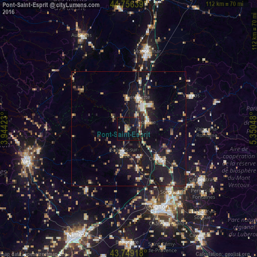
Analysis of Pont-Saint-Esprit night lights 2016
Square area 10x10 km:
 0%
0%90-99
3.03%80-89
0.61%70-79
2.58%60-69
3.33%50-59
2.58%40-49
0.61%30-39
1.21%20-29
1.06%10-19
19.85%0-9
65.15%Square area 50x50 km:
0.9%90-99
1.74%80-89
1.27%70-79
1.35%60-69
1.72%50-59
1.23%40-49
1.57%30-39
1.25%20-29
2.72%10-19
16.26%0-9
69.99%Clear (daylight) street map image can be seen on geolist.org.
Map coordinates:
44° 45' 23" North, 3° 56' 39.2" East
44° 15' 17.8" North, 4° 38' 50.5" East
43° 44' 57" North, 5° 21' 1.7" East
Some cities around Pont-Saint-Esprit sort by population:
• Orange
18.4 km =11.4 mi,  135°
135°
• Bagnols-sur-Cèze
10.8 km =6.7 mi,  192°
192°
• Bollène
8.6 km =5.3 mi,  70°
70°
• Pierrelatte
14.1 km =8.8 mi,  18°
18°
• Bourg-Saint-Andéol
13.2 km =8.2 mi,  358°
358°
• Saint-Paul-Trois-Châteaux
13.7 km =8.5 mi,  42°
42°
• Laudun-l'Ardoise
17.3 km =10.7 mi,  174°
174°
• Roquemaure
25.1 km =15.6 mi,  155°
155°
2986109 (p: 10,002)
Sources (retrieved 2019-11-25):
» Earth at Night: Flat Maps 2012, 2016