Nœux-les-Mines night lights from space
Night Light of Nœux-les-Mines (Hauts-de-France) from space (France) Src. Average luminocity for 10x10km area is 72.6345% and for 50x50km: 33.2451%.
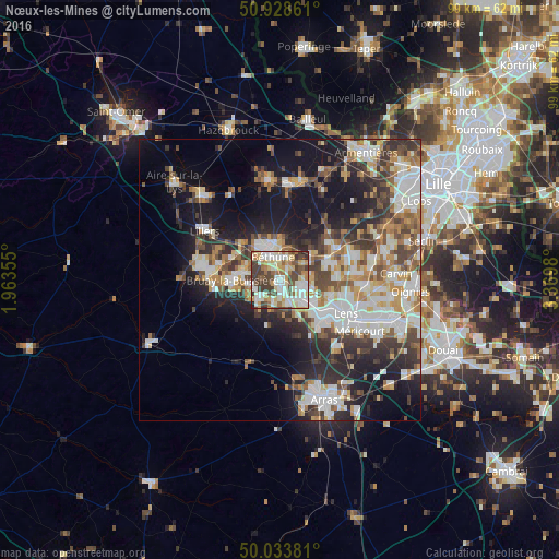
Analysis of Nœux-les-Mines night lights 2016
Square area 10x10 km:
 14.57%
90-99
22.83%80-89
12.75%70-79
7.84%60-69
8.12%50-59
7.42%40-49
11.62%30-39
13.31%20-29
1.54%10-19
0%0-9
0%Square area 50x50 km:
6.7%90-99
7.58%80-89
3.3%70-79
3.66%60-69
3.96%50-59
3.94%40-49
4.91%30-39
5.6%20-29
8.25%10-19
15.32%0-9
36.77%Clear (daylight) street map image can be seen on geolist.org.
Map coordinates:
50° 55' 43" North, 1° 57' 48.8" East
50° 28' 60" North, 2° 40' 0" East
50° 2' 1.7" North, 3° 22' 11.3" East
Some cities around Nœux-les-Mines sort by population:
• Béthune
5.5 km =3.4 mi,  339°
339°
• Bully-les-Mines
6.1 km =3.8 mi,  135°
135°
• Beuvry
3.9 km =2.4 mi,  19°
19°
• Barlin
4.8 km =3 mi,  224°
224°
• Mazingarbe
3.7 km =2.3 mi,  111°
111°
• Hersin-Coupigny
4.1 km =2.5 mi,  197°
197°
• Sains-en-Gohelle
4.4 km =2.7 mi,  164°
164°
• Annezin
6.4 km =4 mi,  327°
327°
2990287 (p: 11,970)
Sources (retrieved 2019-11-25):
» Earth at Night: Flat Maps 2012, 2016