Magny-les-Hameaux night lights from space
Night Light of Magny-les-Hameaux (Île-de-France) from space (France) Src. Average luminocity for 10x10km area is 58.4985% and for 50x50km: 48.7079%.
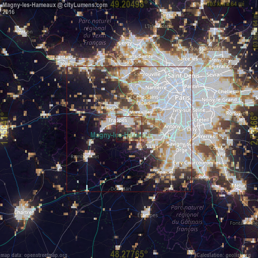
Analysis of Magny-les-Hameaux night lights 2016
Square area 10x10 km:
 12.5%
12.5%90-99
14.29%80-89
5.51%70-79
4.32%60-69
10.12%50-59
5.8%40-49
8.63%30-39
20.68%20-29
11.01%10-19
6.1%0-9
1.04%Square area 50x50 km:
20.1%90-99
11.22%80-89
3.62%70-79
3.44%60-69
4.48%50-59
3.56%40-49
4.63%30-39
4.21%20-29
5.94%10-19
10.26%0-9
28.55%Clear (daylight) street map image can be seen on geolist.org.
Map coordinates:
49° 12' 17.9" North, 1° 21' 30.3" East
48° 44' 36.4" North, 2° 3' 41.5" East
48° 16' 39.5" North, 2° 45' 52.8" East
Some cities around Magny-les-Hameaux sort by population:
• Saint-Quentin-en-Yvelines
4.4 km =2.7 mi,  315°
315°
• Montigny-le-Bretonneux
3.2 km =2 mi, 321°
• Guyancourt
3.4 km =2.1 mi,  15°
15°
• Trappes
4.7 km =2.9 mi, 316°
• Voisins-le-Bretonneux
1.8 km =1.1 mi,  335°
335°
• Saint-Rémy-lès-Chevreuse
4.2 km =2.6 mi,  164°
164°
• Buc
6 km =3.7 mi,  52°
52°
• Chevreuse
4.6 km =2.9 mi,  206°
206°
2996752 (p: 9,203)
Sources (retrieved 2019-11-25):
» Earth at Night: Flat Maps 2012, 2016