Lourdes night lights from space
Night Light of Lourdes (Occitanie) from space (France) Src. Average luminocity for 10x10km area is 13.3015% and for 50x50km: 6.3751%.
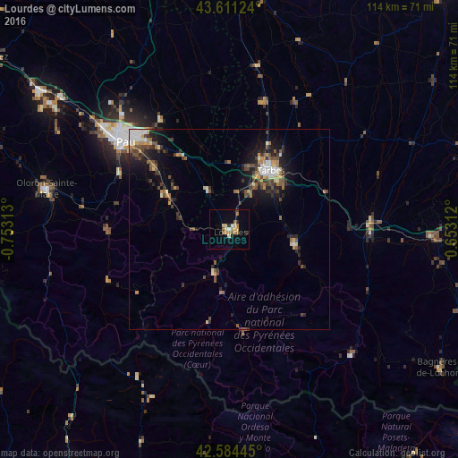
Analysis of Lourdes night lights 2016
Square area 10x10 km:
 0%
0%90-99
1.82%80-89
2.58%70-79
2.27%60-69
2.88%50-59
1.97%40-49
0.91%30-39
1.06%20-29
1.21%10-19
2.27%0-9
83.03%Square area 50x50 km:
0.51%90-99
0.91%80-89
0.61%70-79
0.77%60-69
0.97%50-59
0.96%40-49
1.31%30-39
1.24%20-29
1.68%10-19
3.63%0-9
87.39%Clear (daylight) street map image can be seen on geolist.org.
Map coordinates:
43° 36' 40.5" North, 0° 45' 11.3" West
43° 6' 0" North, 0° 3' 0" West
42° 35' 4" North, 0° 39' 11.2" East
Some cities around Lourdes sort by population:
• Pau
34 km =21.1 mi,  310°
310°
• Tarbes
18.3 km =11.4 mi,  36°
36°
• Bagnères-de-Bigorre
16.7 km =10.4 mi,  103°
103°
• Aureilhan
19.8 km =12.3 mi, 36°
• Jurançon
34.4 km =21.4 mi, 307°
• Vic-en-Bigorre
33 km =20.5 mi,  14°
14°
• Gan
30.8 km =19.1 mi,  298°
298°
• Bizanos
31.7 km =19.7 mi, 309°
2997395 (p: 15,786)
Sources (retrieved 2019-11-25):
» Earth at Night: Flat Maps 2012, 2016