Linselles night lights from space
Night Light of Linselles (Hauts-de-France) from space (France) Src. Average luminocity for 10x10km area is 73.3463% and for 50x50km: 45.2005%.
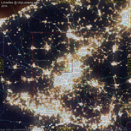
Analysis of Linselles night lights 2016
Square area 10x10 km:
 18.98%
90-99
14.97%80-89
11.23%70-79
16.18%60-69
9.89%50-59
5.88%40-49
9.49%30-39
11.9%20-29
1.47%10-19
0%0-9
0%Square area 50x50 km:
10.92%90-99
8.55%80-89
4%70-79
4.89%60-69
6.08%50-59
6.84%40-49
6.88%30-39
7.8%20-29
11.75%10-19
14.42%0-9
17.88%Clear (daylight) street map image can be seen on geolist.org.
Map coordinates:
51° 10' 47.9" North, 2° 22' 32.4" East
50° 44' 13.5" North, 3° 4' 43.6" East
50° 17' 23.9" North, 3° 46' 54.9" East
Some cities around Linselles sort by population:
• Tourcoing
6 km =3.7 mi,  104°
104°
• Wervik, BE
5.6 km =3.5 mi,  329°
329°
• Roncq
3.5 km =2.2 mi,  58°
58°
• Mouvaux
5.7 km =3.5 mi,  136°
136°
• Comines
5.5 km =3.4 mi,  299°
299°
• Bondues
4.1 km =2.5 mi,  163°
163°
• Neuville-en-Ferrain
5.6 km =3.5 mi,  77°
77°
• Quesnoy-sur-Deûle
6.1 km =3.8 mi,  244°
244°
2998209 (p: 8,049)
Sources (retrieved 2019-11-25):
» Earth at Night: Flat Maps 2012, 2016