Comines night lights from space
Night Light of Comines (Hauts-de-France) from space (France) Src. Average luminocity for 10x10km area is 48.1863% and for 50x50km: 41.7598%.
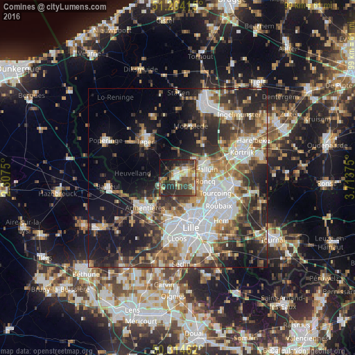
Analysis of Comines night lights 2016
Square area 10x10 km:
 4.48%
4.48%90-99
8.82%80-89
5.6%70-79
5.74%60-69
8.12%50-59
7.98%40-49
14.01%30-39
13.03%20-29
17.37%10-19
12.04%0-9
2.8%Square area 50x50 km:
10.45%90-99
7.91%80-89
3.58%70-79
4.5%60-69
5.33%50-59
6%40-49
5.9%30-39
7.09%20-29
10.76%10-19
15.27%0-9
23.21%Clear (daylight) street map image can be seen on geolist.org.
Map coordinates:
51° 12' 14.9" North, 2° 18' 27" East
50° 45' 41.4" North, 3° 0' 38.3" East
50° 18' 52.6" North, 3° 42' 49.5" East
Some cities around Comines sort by population:
• Menen, BE
8.8 km =5.5 mi,  63°
63°
• Halluin
8.6 km =5.3 mi,  71°
71°
• Wervik, BE
2.9 km =1.8 mi,  42°
42°
• Roncq
7.8 km =4.8 mi,  96°
96°
• Bondues
8.9 km =5.5 mi,  138°
138°
• Wambrechies
9.1 km =5.7 mi,  163°
163°
• Linselles
5.5 km =3.4 mi,  119°
119°
• Quesnoy-sur-Deûle
5.4 km =3.4 mi,  188°
188°
3024102 (p: 12,548)
Sources (retrieved 2019-11-25):
» Earth at Night: Flat Maps 2012, 2016