Yvetot night lights from space
Night Light of Yvetot (Normandy) from space (France) Src. Average luminocity for 10x10km area is 12.0518% and for 50x50km: 8.5492%.
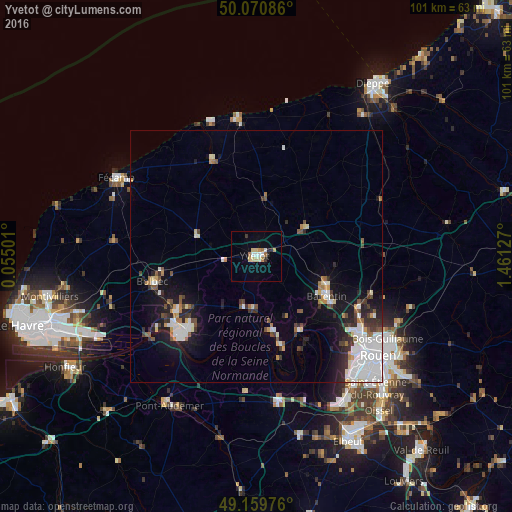
Analysis of Yvetot night lights 2016
Square area 10x10 km:
 1.68%
1.68%90-99
1.68%80-89
2.8%70-79
1.4%60-69
1.96%50-59
0%40-49
0%30-39
1.54%20-29
1.26%10-19
1.12%0-9
86.55%Square area 50x50 km:
2.4%90-99
1.48%80-89
0.6%70-79
0.61%60-69
0.77%50-59
0.72%40-49
0.78%30-39
1.28%20-29
1.69%10-19
4.89%0-9
84.77%Clear (daylight) street map image can be seen on geolist.org.
Map coordinates:
50° 4' 15.1" North, 0° 3' 18" East
49° 37' 2.8" North, 0° 45' 29.3" East
49° 9' 35.1" North, 1° 27' 40.6" East
Some cities around Yvetot sort by population:
• Barentin
16.3 km =10.1 mi,  119°
119°
• Bolbec
21.1 km =13.1 mi,  256°
256°
• Maromme
24.6 km =15.3 mi,  128°
128°
• Lillebonne
19.3 km =12 mi,  235°
235°
• Notre-Dame-de-Gravenchon
19.6 km =12.2 mi,  223°
223°
• Pavilly
15.2 km =9.4 mi,  111°
111°
• Malaunay
22.9 km =14.2 mi, 116°
• Le Trait
17 km =10.6 mi,  165°
165°
2967189 (p: 11,232)
Sources (retrieved 2019-11-25):
» Earth at Night: Flat Maps 2012, 2016