Le Soler night lights from space
Night Light of Le Soler (Occitanie) from space (France) Src. Average luminocity for 10x10km area is 41.8636% and for 50x50km: 15.4674%.
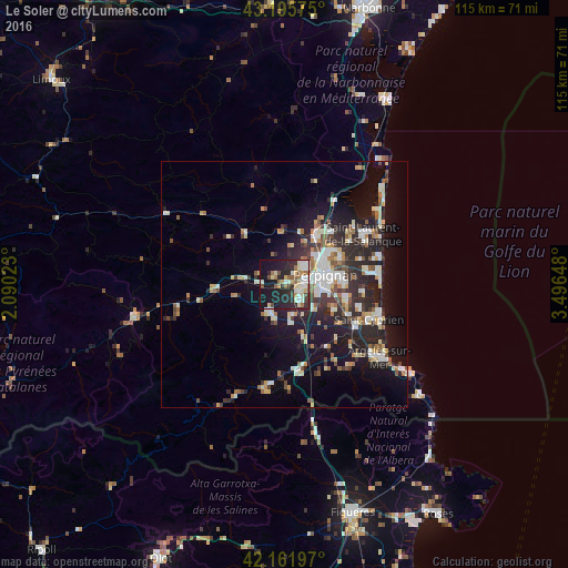
Analysis of Le Soler night lights 2016
Square area 10x10 km:
 6.06%
6.06%90-99
9.7%80-89
6.52%70-79
3.18%60-69
5%50-59
4.85%40-49
5.3%30-39
3.18%20-29
19.09%10-19
28.64%0-9
8.48%Square area 50x50 km:
2.18%90-99
3.17%80-89
1.71%70-79
1.33%60-69
1.68%50-59
1.69%40-49
1.72%30-39
2.38%20-29
6.11%10-19
10.77%0-9
67.25%Clear (daylight) street map image can be seen on geolist.org.
Map coordinates:
43° 11' 44.7" North, 2° 5' 24.8" East
42° 40' 51.6" North, 2° 47' 36.1" East
42° 9' 43.1" North, 3° 29' 47.3" East
Some cities around Le Soler sort by population:
• Perpignan
8.5 km =5.3 mi,  77°
77°
• Saint-Estève
5.4 km =3.4 mi,  50°
50°
• Cabestany
12.1 km =7.5 mi,  89°
89°
• Rivesaltes
11.8 km =7.3 mi,  33°
33°
• Thuir
6.2 km =3.9 mi,  210°
210°
• Bompas
12.8 km =8 mi,  63°
63°
• Toulouges
3.3 km =2.1 mi,  112°
112°
• Pia
12.5 km =7.8 mi, 55°
3000139 (p: 6,377)
Sources (retrieved 2019-11-25):
» Earth at Night: Flat Maps 2012, 2016