Beaumont-sur-Oise night lights from space
Night Light of Beaumont-sur-Oise (Île-de-France) from space (France) Src. Average luminocity for 10x10km area is 43.5798% and for 50x50km: 39.6161%.
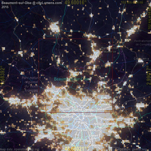
Analysis of Beaumont-sur-Oise night lights 2016
Square area 10x10 km:
 6.86%
6.86%90-99
8.26%80-89
5.74%70-79
4.62%60-69
5.04%50-59
4.76%40-49
5.32%30-39
7.56%20-29
21.85%10-19
29.97%0-9
0%Square area 50x50 km:
12.86%90-99
8.76%80-89
3.55%70-79
3.22%60-69
3.78%50-59
3.97%40-49
4%30-39
3.95%20-29
7.72%10-19
15.4%0-9
32.81%Clear (daylight) street map image can be seen on geolist.org.
Map coordinates:
49° 36' 0.6" North, 1° 35' 2.1" East
49° 8' 32.4" North, 2° 17' 13.4" East
48° 40' 48.8" North, 2° 59' 24.6" East
Some cities around Beaumont-sur-Oise sort by population:
• L’Isle-Adam
5.8 km =3.6 mi,  227°
227°
• Gouvieux
10.5 km =6.5 mi,  61°
61°
• Chambly
3.8 km =2.4 mi,  315°
315°
• Méry-sur-Oise
11.6 km =7.2 mi,  216°
216°
• Persan
1.6 km =1 mi, 318°
• Auvers-sur-Oise
11.6 km =7.2 mi, 227°
• Bouffémont
11 km =6.8 mi,  175°
175°
• Parmain
6.2 km =3.9 mi,  237°
237°
3034141 (p: 9,011)
Sources (retrieved 2019-11-25):
» Earth at Night: Flat Maps 2012, 2016