La Pomme night lights from space
Night Light of La Pomme (Provence-Alpes-Côte d'Azur) from space (France) Src. Average luminocity for 10x10km area is 83.9197% and for 50x50km: 28.0774%.
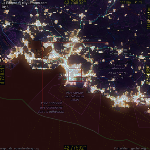
Analysis of La Pomme night lights 2016
Square area 10x10 km:
 46.52%
90-99
23.79%80-89
2.12%70-79
2.73%60-69
5.3%50-59
2.88%40-49
1.36%30-39
9.24%20-29
6.06%10-19
0%0-9
0%Square area 50x50 km:
6.34%90-99
6.14%80-89
2.83%70-79
2.14%60-69
2.86%50-59
2.94%40-49
3.32%30-39
5.23%20-29
9.82%10-19
13.91%0-9
44.47%Clear (daylight) street map image can be seen on geolist.org.
Map coordinates:
43° 47' 58.3" North, 4° 44' 18.3" East
43° 17' 23.5" North, 5° 26' 29.5" East
42° 46' 33.3" North, 6° 8' 40.8" East
Some cities around La Pomme sort by population:
• Marseille 12
0.8 km =0.5 mi,  328°
328°
• Marseille 11
0.3 km =0.2 mi,  290°
290°
• Saint-Loup
1.6 km =1 mi,  211°
211°
• Saint-Marcel
2 km =1.2 mi,  97°
97°
• La Valbarelle
1.1 km =0.7 mi,  118°
118°
• Les Caillols
1.5 km =0.9 mi,  21°
21°
• La Fourragère
1.8 km =1.1 mi, 332°
• La Timone
2.2 km =1.4 mi,  265°
265°
3007221 (p: 17,787)
Sources (retrieved 2019-11-25):
» Earth at Night: Flat Maps 2012, 2016