Les Caillols night lights from space
Night Light of Les Caillols (Provence-Alpes-Côte d'Azur) from space (France) Src. Average luminocity for 10x10km area is 85.4379% and for 50x50km: 28.9835%.
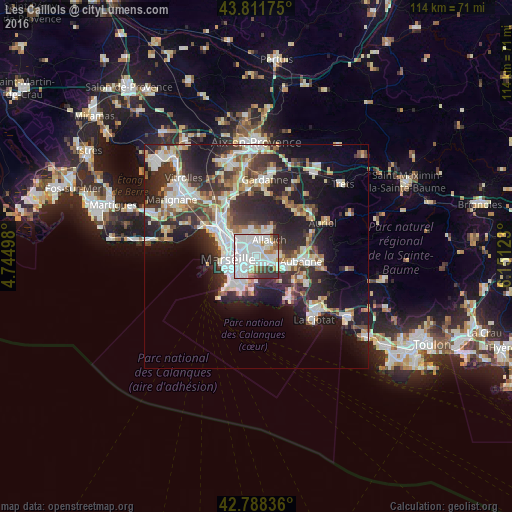
Analysis of Les Caillols night lights 2016
Square area 10x10 km:
 45%
45%90-99
27.12%80-89
2.27%70-79
2.58%60-69
5.3%50-59
3.18%40-49
1.67%30-39
10.45%20-29
2.42%10-19
0%0-9
0%Square area 50x50 km:
6.53%90-99
6.33%80-89
2.96%70-79
2.25%60-69
2.88%50-59
3.05%40-49
3.39%30-39
5.42%20-29
10.11%10-19
14.3%0-9
42.77%Clear (daylight) street map image can be seen on geolist.org.
Map coordinates:
43° 48' 42.3" North, 4° 44' 41.9" East
43° 18' 8" North, 5° 26' 53.2" East
42° 47' 18.1" North, 6° 9' 4.4" East
Some cities around Les Caillols sort by population:
• Marseille 12
1.2 km =0.7 mi,  235°
235°
• Marseille 11
1.5 km =0.9 mi,  211°
211°
• La Pomme
1.5 km =0.9 mi,  201°
201°
• Saint-Marcel
2.2 km =1.4 mi,  138°
138°
• Saint-Julien
1.2 km =0.7 mi,  4°
4°
• La Valbarelle
2 km =1.2 mi,  166°
166°
• La Fourragère
1.4 km =0.9 mi,  277°
277°
• Les Trois-Lucs
1.7 km =1.1 mi,  42°
42°
11919771 (p: 9,742)
Sources (retrieved 2019-11-25):
» Earth at Night: Flat Maps 2012, 2016