L’Isle-sur-la-Sorgue night lights from space
Night Light of L’Isle-sur-la-Sorgue (Provence-Alpes-Côte d'Azur) from space (France) Src. Average luminocity for 10x10km area is 24.7603% and for 50x50km: 18.74%.
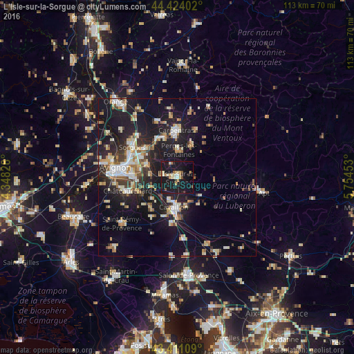
Analysis of L’Isle-sur-la-Sorgue night lights 2016
Square area 10x10 km:
 1.43%
1.43%90-99
3.65%80-89
4.76%70-79
2.22%60-69
3.81%50-59
2.06%40-49
1.27%30-39
1.43%20-29
2.86%10-19
55.24%0-9
21.27%Square area 50x50 km:
2.34%90-99
3.63%80-89
2.29%70-79
2.12%60-69
2.19%50-59
1.9%40-49
1.88%30-39
2.25%20-29
5.03%10-19
20.37%0-9
55.98%Clear (daylight) street map image can be seen on geolist.org.
Map coordinates:
44° 25' 26.5" North, 4° 20' 53.8" East
43° 55' 11" North, 5° 3' 5.1" East
43° 24' 39.9" North, 5° 45' 16.3" East
Some cities around L’Isle-sur-la-Sorgue sort by population:
• Cavaillon
9.9 km =6.2 mi,  187°
187°
• Montfavet
14.3 km =8.9 mi,  276°
276°
• Pernes-les-Fontaines
8.7 km =5.4 mi,  4°
4°
• Monteux
13.7 km =8.5 mi,  341°
341°
• Vedène
13.4 km =8.3 mi,  298°
298°
• Entraigues-sur-la-Sorgue
13.6 km =8.5 mi,  312°
312°
• Le Thor
4.6 km =2.9 mi, 283°
• Morières-lès-Avignon
12.3 km =7.6 mi, 280°
2998127 (p: 16,968)
Sources (retrieved 2019-11-25):
» Earth at Night: Flat Maps 2012, 2016