Saint-Clément-de-Rivière night lights from space
Night Light of Saint-Clément-de-Rivière (Occitanie) from space (France) Src. Average luminocity for 10x10km area is 48.4636% and for 50x50km: 19.4041%.
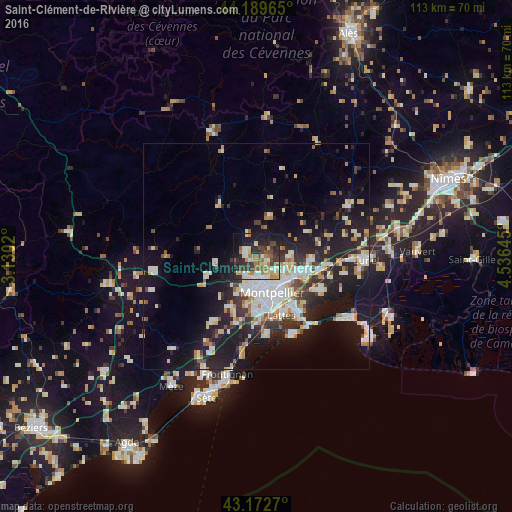
Analysis of Saint-Clément-de-Rivière night lights 2016
Square area 10x10 km:
 6.82%
6.82%90-99
9.09%80-89
6.52%70-79
7.73%60-69
7.58%50-59
5.61%40-49
7.27%30-39
10.76%20-29
13.94%10-19
21.52%0-9
3.18%Square area 50x50 km:
3.69%90-99
4.19%80-89
2.05%70-79
1.86%60-69
2.22%50-59
1.45%40-49
1.61%30-39
2.62%20-29
6.34%10-19
14.98%0-9
58.99%Clear (daylight) street map image can be seen on geolist.org.
Map coordinates:
44° 11' 22.7" North, 3° 7' 48.7" East
43° 40' 60" North, 3° 49' 60" East
43° 10' 21.7" North, 4° 32' 11.2" East
Some cities around Saint-Clément-de-Rivière sort by population:
• Montpellier
8.8 km =5.5 mi,  156°
156°
• Castelnau-le-Lez
7.7 km =4.8 mi,  136°
136°
• Le Crès
9.4 km =5.8 mi,  114°
114°
• Juvignac
7.9 km =4.9 mi,  193°
193°
• Grabels
4.8 km =3 mi,  215°
215°
• Vendargues
11.3 km =7 mi,  104°
104°
• Clapiers
5.3 km =3.3 mi,  121°
121°
• Jacou
6.8 km =4.2 mi, 111°
2981073 (p: 5,216)
Sources (retrieved 2019-11-25):
» Earth at Night: Flat Maps 2012, 2016