Tain-l’Hermitage night lights from space
Night Light of Tain-l’Hermitage (Auvergne-Rhône-Alpes) from space (France) Src. Average luminocity for 10x10km area is 22.8879% and for 50x50km: 10.5972%.
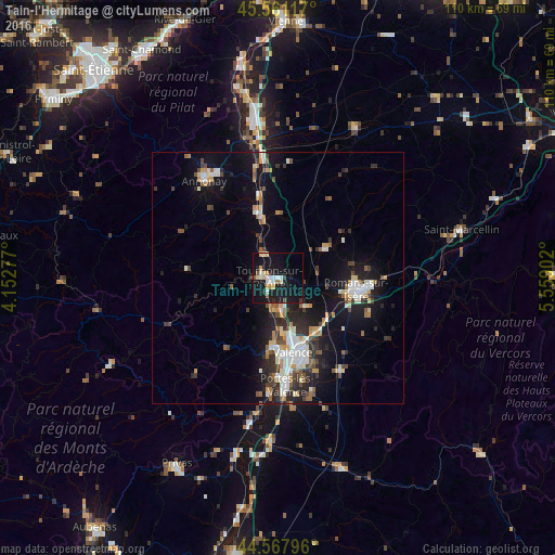
Analysis of Tain-l’Hermitage night lights 2016
Square area 10x10 km:
 3.48%
3.48%90-99
3.79%80-89
3.64%70-79
2.88%60-69
0.76%50-59
2.12%40-49
0.91%30-39
0.61%20-29
4.55%10-19
40.3%0-9
36.97%Square area 50x50 km:
1.5%90-99
2.07%80-89
0.96%70-79
1%60-69
1.09%50-59
1.23%40-49
1.47%30-39
1.33%20-29
3.05%10-19
9.02%0-9
77.27%Clear (daylight) street map image can be seen on geolist.org.
Map coordinates:
45° 33' 40.2" North, 4° 9' 10" East
45° 4' 0.2" North, 4° 51' 21.2" East
44° 34' 4.7" North, 5° 33' 32.5" East
Some cities around Tain-l’Hermitage sort by population:
• Valence
16.2 km =10.1 mi,  164°
164°
• Romans-sur-Isère
16.6 km =10.3 mi,  96°
96°
• Bourg-lès-Valence
13.7 km =8.5 mi,  167°
167°
• Guilherand-Granges
15 km =9.3 mi, 174°
• Tournon-sur-Rhône
1.8 km =1.1 mi,  269°
269°
• Bourg-de-Péage
15.7 km =9.8 mi, 104°
• Portes-lès-Valence
21.3 km =13.2 mi,  176°
176°
• Saint-Péray
13.2 km =8.2 mi, 183°
2973531 (p: 5,923)
Sources (retrieved 2019-11-25):
» Earth at Night: Flat Maps 2012, 2016