Bouc-Bel-Air night lights from space
Night Light of Bouc-Bel-Air (Provence-Alpes-Côte d'Azur) from space (France) Src. Average luminocity for 10x10km area is 63.6921% and for 50x50km: 32.442%.
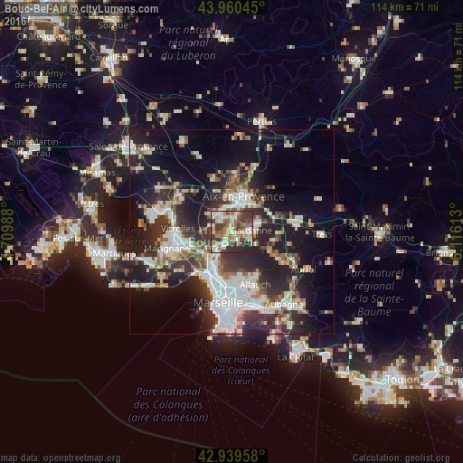
Analysis of Bouc-Bel-Air night lights 2016
Square area 10x10 km:
 8.73%
8.73%90-99
14.29%80-89
12.54%70-79
7.3%60-69
9.37%50-59
10.63%40-49
12.38%30-39
15.56%20-29
9.21%10-19
0%0-9
0%Square area 50x50 km:
6.77%90-99
6.86%80-89
3.4%70-79
2.77%60-69
3.06%50-59
3.72%40-49
3.84%30-39
6%20-29
11.23%10-19
17.46%0-9
34.9%Clear (daylight) street map image can be seen on geolist.org.
Map coordinates:
43° 57' 37.6" North, 4° 42' 35.6" East
43° 27' 7.8" North, 5° 24' 46.8" East
42° 56' 22.5" North, 6° 6' 58.1" East
Some cities around Bouc-Bel-Air sort by population:
• Aix-en-Provence
9 km =5.6 mi,  19°
19°
• Gardanne
4.5 km =2.8 mi,  86°
86°
• Les Pennes-Mirabeau
9.7 km =6 mi,  241°
241°
• Notre-Dame Limite
8.8 km =5.5 mi,  207°
207°
• Septèmes-les-Vallons
7.1 km =4.4 mi, 212°
• Cabriès
3 km =1.9 mi,  246°
246°
• Saint-Antoine
10 km =6.2 mi, 205°
• Simiane-Collongue
3 km =1.9 mi,  143°
143°
3031387 (p: 13,184)
Sources (retrieved 2019-11-25):
» Earth at Night: Flat Maps 2012, 2016