Étréchy night lights from space
Night Light of Étréchy (Île-de-France) from space (France) Src. Average luminocity for 10x10km area is 14% and for 50x50km: 20.193%.
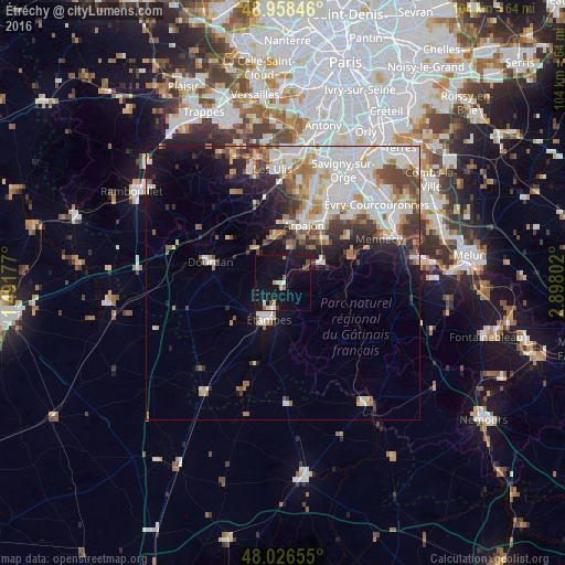
Analysis of Étréchy night lights 2016
Square area 10x10 km:
 1.42%
1.42%90-99
1.42%80-89
1.14%70-79
1.56%60-69
1.14%50-59
1.99%40-49
1.56%30-39
0.57%20-29
0%10-19
24.01%0-9
65.2%Square area 50x50 km:
5.49%90-99
5.12%80-89
1.7%70-79
1.99%60-69
2.28%50-59
1.93%40-49
2.4%30-39
2.07%20-29
2.98%10-19
6.37%0-9
67.65%Clear (daylight) street map image can be seen on geolist.org.
Map coordinates:
48° 57' 30.5" North, 1° 29' 30.4" East
48° 29' 40.7" North, 2° 11' 41.6" East
48° 1' 35.6" North, 2° 53' 52.9" East
Some cities around Étréchy sort by population:
• Étampes
7 km =4.3 mi,  199°
199°
• Dourdan
14 km =8.7 mi,  285°
285°
• Arpajon
11.1 km =6.9 mi,  20°
20°
• Saint-Germain-lès-Arpajon
12.5 km =7.8 mi, 24°
• Breuillet
8.6 km =5.3 mi,  349°
349°
• Ballancourt-sur-Essonne
14.5 km =9 mi,  76°
76°
• Itteville
11.2 km =7 mi, 78°
• Égly
9.5 km =5.9 mi,  13°
13°
3019372 (p: 6,461)
Sources (retrieved 2019-11-25):
» Earth at Night: Flat Maps 2012, 2016