Dourdan night lights from space
Night Light of Dourdan (Île-de-France) from space (France) Src. Average luminocity for 10x10km area is 8.0866% and for 50x50km: 16.6223%.
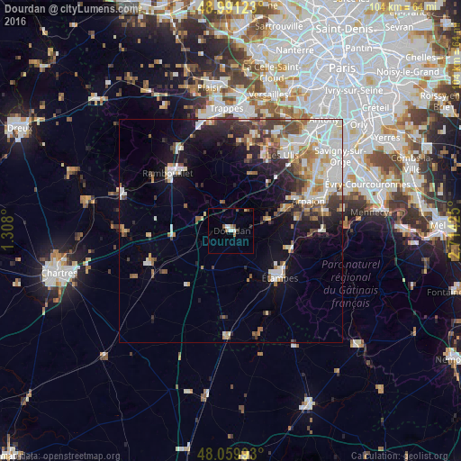
Analysis of Dourdan night lights 2016
Square area 10x10 km:
 1.56%
1.56%90-99
1.28%80-89
0.57%70-79
0%60-69
1.56%50-59
0.99%40-49
1.56%30-39
0.43%20-29
1.14%10-19
0%0-9
90.91%Square area 50x50 km:
3.72%90-99
3.82%80-89
1.58%70-79
1.61%60-69
2.15%50-59
1.67%40-49
1.96%30-39
2.09%20-29
2.95%10-19
6.84%0-9
71.62%Clear (daylight) street map image can be seen on geolist.org.
Map coordinates:
48° 59' 28.4" North, 1° 18' 28.8" East
48° 31' 39.8" North, 2° 0' 40.1" East
48° 3' 35.7" North, 2° 42' 51.3" East
Some cities around Dourdan sort by population:
• Rambouillet
18.5 km =11.5 mi,  314°
314°
• Étampes
15.2 km =9.4 mi,  132°
132°
• Arpajon
18.6 km =11.6 mi,  68°
68°
• Breuillet
12.9 km =8 mi, 68°
• Étréchy
14 km =8.7 mi,  105°
105°
• Limours
14 km =8.7 mi,  20°
20°
• Saint-Arnoult-en-Yvelines
7.1 km =4.4 mi, 312°
• Égly
16.7 km =10.4 mi, 70°
3020925 (p: 10,261)
Sources (retrieved 2019-11-25):
» Earth at Night: Flat Maps 2012, 2016