Divion night lights from space
Night Light of Divion (Hauts-de-France) from space (France) Src. Average luminocity for 10x10km area is 44.1275% and for 50x50km: 20.3507%.
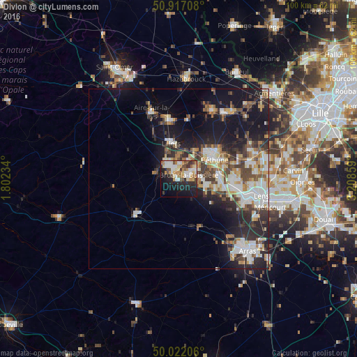
Analysis of Divion night lights 2016
Square area 10x10 km:
 7.98%
7.98%90-99
10.22%80-89
5.18%70-79
6.44%60-69
5.46%50-59
3.5%40-49
6.16%30-39
3.22%20-29
15.27%10-19
23.95%0-9
12.61%Square area 50x50 km:
3.63%90-99
4.31%80-89
2.08%70-79
1.96%60-69
2.27%50-59
2.33%40-49
3.08%30-39
3.28%20-29
6.68%10-19
13.16%0-9
57.24%Clear (daylight) street map image can be seen on geolist.org.
Map coordinates:
50° 55' 1.5" North, 1° 48' 8.4" East
50° 28' 18.1" North, 2° 30' 19.7" East
50° 1' 19.4" North, 3° 12' 30.9" East
Some cities around Divion sort by population:
• Bruay-la-Buissière
3.4 km =2.1 mi,  67°
67°
• Auchel
4.2 km =2.6 mi,  327°
327°
• Barlin
8.4 km =5.2 mi,  104°
104°
• Houdain
3.3 km =2.1 mi,  135°
135°
• Marles-les-Mines
3.7 km =2.3 mi,  3°
3°
• Calonne-Ricouart
2.7 km =1.7 mi,  303°
303°
• Annezin
10.4 km =6.5 mi,  49°
49°
• Haillicourt
4.9 km =3 mi,  85°
85°
3021298 (p: 7,290)
Sources (retrieved 2019-11-25):
» Earth at Night: Flat Maps 2012, 2016