Bruay-la-Buissière night lights from space
Night Light of Bruay-la-Buissière (Hauts-de-France) from space (France) Src. Average luminocity for 10x10km area is 58.6863% and for 50x50km: 23.719%.

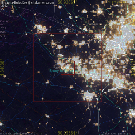
Analysis of Bruay-la-Buissière night lights 2016
Square area 10x10 km:
 8.4%
8.4%90-99
15.69%80-89
7.98%70-79
8.96%60-69
7.7%50-59
8.26%40-49
6.86%30-39
12.61%20-29
14.57%10-19
8.82%0-9
0.14%Square area 50x50 km:
4.34%90-99
5.1%80-89
2.51%70-79
2.27%60-69
2.74%50-59
2.58%40-49
3.55%30-39
3.87%20-29
7.26%10-19
14.79%0-9
50.98%Clear (daylight) street map image can be seen on geolist.org.
Map coordinates:
50° 55' 43" North, 1° 50' 48.8" East
50° 28' 60" North, 2° 33' 0" East
50° 2' 1.7" North, 3° 15' 11.3" East
Some cities around Bruay-la-Buissière sort by population:
• Auchel
5.9 km =3.7 mi,  292°
292°
• Barlin
6 km =3.7 mi,  124°
124°
• Houdain
3.8 km =2.4 mi,  193°
193°
• Divion
3.4 km =2.1 mi,  247°
247°
• Marles-les-Mines
3.8 km =2.4 mi,  309°
309°
• Calonne-Ricouart
5.4 km =3.4 mi,  272°
272°
• Annezin
7.2 km =4.5 mi,  41°
41°
• Haillicourt
2 km =1.2 mi, 117°
3029825 (p: 24,474)
Sources (retrieved 2019-11-25):
» Earth at Night: Flat Maps 2012, 2016