Chinon night lights from space
Night Light of Chinon (Centre) from space (France) Src. Average luminocity for 10x10km area is 5.7991% and for 50x50km: 1.7519%.
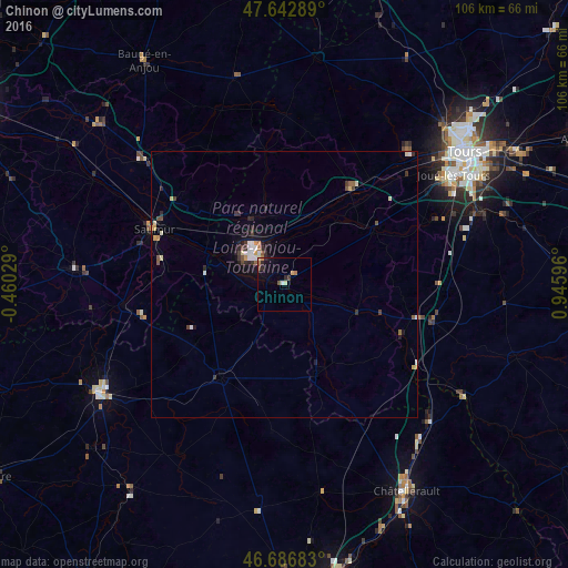
Analysis of Chinon night lights 2016
Square area 10x10 km:
 0.3%
0.3%90-99
1.04%80-89
0.6%70-79
0.15%60-69
1.49%50-59
0.6%40-49
0.6%30-39
0.6%20-29
1.93%10-19
2.38%0-9
90.33%Square area 50x50 km:
0.18%90-99
0.3%80-89
0.23%70-79
0.15%60-69
0.17%50-59
0.21%40-49
0.27%30-39
0.31%20-29
0.49%10-19
0.89%0-9
96.82%Clear (daylight) street map image can be seen on geolist.org.
Map coordinates:
47° 38' 34.4" North, 0° 27' 37" West
47° 10' 1.2" North, 0° 14' 34.2" East
46° 41' 12.6" North, 0° 56' 45.5" East
Some cities around Chinon sort by population:
• Joué-lès-Tours
38.2 km =23.7 mi,  57°
57°
• Saumur
26.3 km =16.3 mi,  292°
292°
• Fondettes
37.5 km =23.3 mi,  45°
45°
• Loudun
21.4 km =13.3 mi,  214°
214°
• Doué-la-Fontaine
39.2 km =24.4 mi,  274°
274°
• Ballan-Miré
34.1 km =21.2 mi, 55°
• Monts
31.3 km =19.4 mi,  66°
66°
• Luynes
33.7 km =20.9 mi,  44°
44°
3025132 (p: 9,405)
Sources (retrieved 2019-11-25):
» Earth at Night: Flat Maps 2012, 2016