Ballan-Miré night lights from space
Night Light of Ballan-Miré (Centre) from space (France) Src. Average luminocity for 10x10km area is 28.9435% and for 50x50km: 6.5628%.
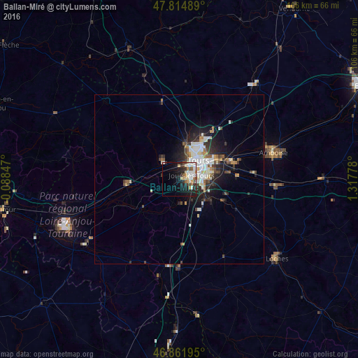
Analysis of Ballan-Miré night lights 2016
Square area 10x10 km:
 4.61%
4.61%90-99
8.78%80-89
4.02%70-79
2.98%60-69
1.34%50-59
2.23%40-49
2.83%30-39
2.98%20-29
8.04%10-19
18.15%0-9
44.05%Square area 50x50 km:
1.14%90-99
1.66%80-89
0.65%70-79
0.59%60-69
0.52%50-59
0.5%40-49
0.89%30-39
0.89%20-29
2.04%10-19
3.86%0-9
87.25%Clear (daylight) street map image can be seen on geolist.org.
Map coordinates:
47° 48' 53.6" North, 0° 5' 18.5" West
47° 20' 26.1" North, 0° 36' 52.8" East
46° 51' 43" North, 1° 19' 4" East
Some cities around Ballan-Miré sort by population:
• Tours
9 km =5.6 mi,  48°
48°
• Joué-lès-Tours
4.3 km =2.7 mi,  72°
72°
• Saint-Cyr-sur-Loire
7.7 km =4.8 mi,  30°
30°
• Chambray-lès-Tours
6.7 km =4.2 mi,  94°
94°
• Fondettes
7.1 km =4.4 mi,  349°
349°
• La Riche
6.9 km =4.3 mi,  37°
37°
• Monts
7.1 km =4.4 mi,  173°
173°
• Luynes
6.6 km =4.1 mi,  317°
317°
3035226 (p: 7,398)
Sources (retrieved 2019-11-25):
» Earth at Night: Flat Maps 2012, 2016