Fouillard night lights from space
Night Light of Fouillard (Brittany) from space (France) Src. Average luminocity for 10x10km area is 15.0491% and for 50x50km: 6.0572%.
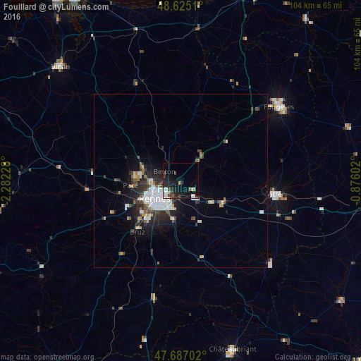
Analysis of Fouillard night lights 2016
Square area 10x10 km:
 3.27%
3.27%90-99
1.19%80-89
2.08%70-79
0.6%60-69
0.6%50-59
0.45%40-49
3.27%30-39
2.53%20-29
6.1%10-19
14.14%0-9
65.77%Square area 50x50 km:
1.57%90-99
1.01%80-89
0.37%70-79
0.42%60-69
0.34%50-59
0.58%40-49
0.91%30-39
1.09%20-29
2.02%10-19
3.46%0-9
88.23%Clear (daylight) street map image can be seen on geolist.org.
Map coordinates:
48° 37' 30.4" North, 2° 16' 56.2" West
48° 9' 29.5" North, 1° 34' 44.9" West
47° 41' 13.3" North, 0° 52' 33.7" West
Some cities around Fouillard sort by population:
• Rennes
8.7 km =5.4 mi,  233°
233°
• Cesson-Sévigné
4.5 km =2.8 mi,  203°
203°
• Betton
5 km =3.1 mi,  299°
299°
• Saint-Grégoire
8 km =5 mi,  264°
264°
• Chantepie
8.2 km =5.1 mi, 199°
• Liffré
8.1 km =5 mi,  40°
40°
• Acigné
4.2 km =2.6 mi,  131°
131°
• Melesse
10.8 km =6.7 mi,  307°
307°
3017592 (p: 6,737)
Sources (retrieved 2019-11-25):
» Earth at Night: Flat Maps 2012, 2016