Vern-sur-Seiche night lights from space
Night Light of Vern-sur-Seiche (Brittany) from space (France) Src. Average luminocity for 10x10km area is 13.2486% and for 50x50km: 6.1002%.
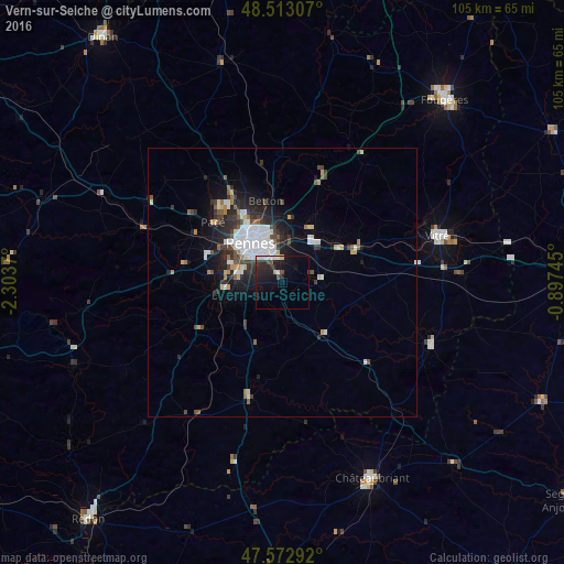
Analysis of Vern-sur-Seiche night lights 2016
Square area 10x10 km:
 2.98%
2.98%90-99
1.85%80-89
0.57%70-79
0.57%60-69
0%50-59
0.57%40-49
2.27%30-39
2.27%20-29
7.95%10-19
13.78%0-9
67.19%Square area 50x50 km:
1.54%90-99
1.05%80-89
0.4%70-79
0.42%60-69
0.36%50-59
0.66%40-49
0.91%30-39
1.09%20-29
2.03%10-19
3.42%0-9
88.12%Clear (daylight) street map image can be seen on geolist.org.
Map coordinates:
48° 30' 47.1" North, 2° 18' 13.3" West
48° 2' 42.5" North, 1° 36' 2.1" West
47° 34' 22.5" North, 0° 53' 50.8" West
Some cities around Vern-sur-Seiche sort by population:
• Rennes
9.2 km =5.7 mi,  323°
323°
• Cesson-Sévigné
8.5 km =5.3 mi,  358°
358°
• Saint-Jacques-de-la-Lande
9.2 km =5.7 mi,  283°
283°
• Chantepie
5 km =3.1 mi,  347°
347°
• Chartres-de-Bretagne
7.8 km =4.8 mi,  265°
265°
• Châteaugiron
7.2 km =4.5 mi,  88°
88°
• Châtillon-sur-Seiche
5.4 km =3.4 mi,  257°
257°
• Acigné
10.9 km =6.8 mi,  25°
25°
2969741 (p: 8,110)
Sources (retrieved 2019-11-25):
» Earth at Night: Flat Maps 2012, 2016