Champigneulles night lights from space
Night Light of Champigneulles (Grand Est) from space (France) Src. Average luminocity for 10x10km area is 56.1458% and for 50x50km: 12.6036%.
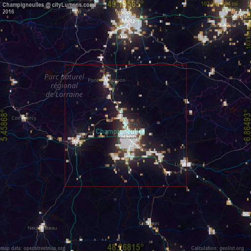
Analysis of Champigneulles night lights 2016
Square area 10x10 km:
 20.83%
90-99
14.73%80-89
2.68%70-79
2.38%60-69
3.13%50-59
3.13%40-49
4.17%30-39
11.31%20-29
22.47%10-19
13.69%0-9
1.49%Square area 50x50 km:
2.93%90-99
2.86%80-89
0.7%70-79
0.82%60-69
0.89%50-59
1.09%40-49
1.18%30-39
1.87%20-29
3.4%10-19
10.58%0-9
73.67%Clear (daylight) street map image can be seen on geolist.org.
Map coordinates:
49° 11' 44.3" North, 5° 27' 31.2" East
48° 44' 2.5" North, 6° 9' 42.5" East
48° 16' 5.3" North, 6° 51' 53.7" East
Some cities around Champigneulles sort by population:
• Nancy
5.8 km =3.6 mi,  162°
162°
• Laxou
5.7 km =3.5 mi,  189°
189°
• Saint-Max
4.7 km =2.9 mi,  135°
135°
• Maxéville
2.3 km =1.4 mi,  171°
171°
• Malzéville
2.9 km =1.8 mi,  145°
145°
• Essey-lès-Nancy
5.8 km =3.6 mi,  124°
124°
• Frouard
3.7 km =2.3 mi,  321°
321°
• Pompey
4.7 km =2.9 mi,  326°
326°
3027126 (p: 6,947)
Sources (retrieved 2019-11-25):
» Earth at Night: Flat Maps 2012, 2016