Bruges night lights from space
Night Light of Bruges (Nouvelle-Aquitaine) from space (France) Src. Average luminocity for 10x10km area is 88.6175% and for 50x50km: 26.9924%.
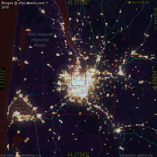
Analysis of Bruges night lights 2016
Square area 10x10 km:
 43.97%
90-99
26.67%80-89
5.08%70-79
4.13%60-69
7.78%50-59
6.98%40-49
3.81%30-39
1.59%20-29
0%10-19
0%0-9
0%Square area 50x50 km:
5.91%90-99
4.88%80-89
2.71%70-79
2.8%60-69
3.63%50-59
3.23%40-49
3.76%30-39
3.78%20-29
6.33%10-19
14.22%0-9
48.75%Clear (daylight) street map image can be seen on geolist.org.
Map coordinates:
45° 22' 33.2" North, 1° 18' 55.2" West
44° 52' 47.3" North, 0° 36' 43.9" West
44° 22' 45.9" North, 0° 5' 27.4" East
Some cities around Bruges sort by population:
• Bordeaux
5 km =3.1 mi,  150°
150°
• Mérignac
5.5 km =3.4 mi,  197°
197°
• Le Bouscat
2.1 km =1.3 mi,  137°
137°
• Lormont
7.5 km =4.7 mi,  94°
94°
• Eysines
2.8 km =1.7 mi,  278°
278°
• Blanquefort
4.1 km =2.5 mi,  332°
332°
• Le Haillan
5.4 km =3.4 mi,  261°
261°
• Le Taillan-Médoc
5.4 km =3.4 mi,  301°
301°
3029799 (p: 12,650)
Sources (retrieved 2019-11-25):
» Earth at Night: Flat Maps 2012, 2016