Blénod-lès-Pont-à-Mousson night lights from space
Night Light of Blénod-lès-Pont-à-Mousson (Grand Est) from space (France) Src. Average luminocity for 10x10km area is 25.6122% and for 50x50km: 11.5225%.
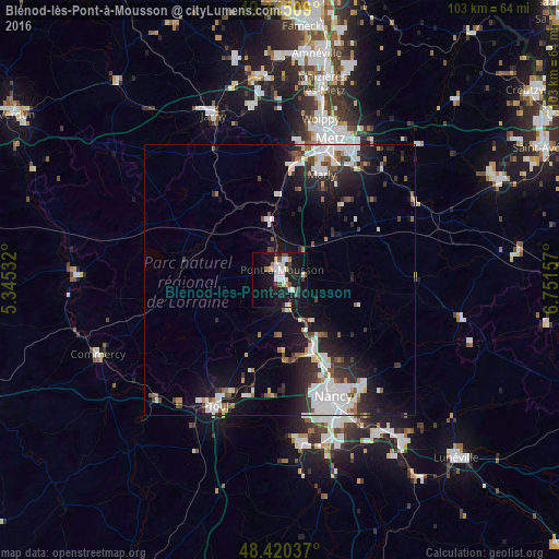
Analysis of Blénod-lès-Pont-à-Mousson night lights 2016
Square area 10x10 km:
 5.97%
5.97%90-99
5.4%80-89
1.14%70-79
2.7%60-69
1.28%50-59
1.85%40-49
2.98%30-39
1.14%20-29
5.4%10-19
36.93%0-9
35.23%Square area 50x50 km:
2.99%90-99
2.5%80-89
0.56%70-79
0.64%60-69
0.82%50-59
1.13%40-49
1.2%30-39
1.75%20-29
3.18%10-19
8.42%0-9
76.81%Clear (daylight) street map image can be seen on geolist.org.
Map coordinates:
49° 20' 42.3" North, 5° 20' 43.2" East
48° 53' 5.5" North, 6° 2' 54.4" East
48° 25' 13.3" North, 6° 45' 5.7" East
Some cities around Blénod-lès-Pont-à-Mousson sort by population:
• Pont-à-Mousson
2.5 km =1.6 mi,  13°
13°
• Marly
21.3 km =13.2 mi,  21°
21°
• Maxéville
21 km =13 mi,  155°
155°
• Frouard
15.1 km =9.4 mi, 156°
• Champigneulles
18.7 km =11.6 mi,  153°
153°
• Liverdun
15.1 km =9.4 mi,  175°
175°
• Pompey
14.1 km =8.8 mi, 156°
• Ars-sur-Moselle
21.5 km =13.4 mi, 5°
3032275 (p: 5,014)
Sources (retrieved 2019-11-25):
» Earth at Night: Flat Maps 2012, 2016