Marly night lights from space
Night Light of Marly (Grand Est) from space (France) Src. Average luminocity for 10x10km area is 47.6994% and for 50x50km: 14.5642%.
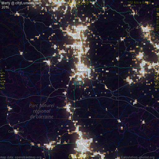
Analysis of Marly night lights 2016
Square area 10x10 km:
 14.88%
90-99
10.71%80-89
1.34%70-79
2.23%60-69
3.57%50-59
4.91%40-49
8.33%30-39
8.78%20-29
17.86%10-19
22.32%0-9
5.06%Square area 50x50 km:
3.54%90-99
3.44%80-89
0.75%70-79
1.01%60-69
1.01%50-59
1.2%40-49
1.66%30-39
2.74%20-29
4.12%10-19
9.54%0-9
70.97%Clear (daylight) street map image can be seen on geolist.org.
Map coordinates:
49° 31' 20.6" North, 5° 27' 4.1" East
49° 3' 49.8" North, 6° 9' 15.4" East
48° 36' 3.5" North, 6° 51' 26.6" East
Some cities around Marly sort by population:
• Metz
6.3 km =3.9 mi,  12°
12°
• Montigny-lès-Metz
3.5 km =2.2 mi,  358°
358°
• Pont-à-Mousson
18.8 km =11.7 mi,  202°
202°
• Woippy
9.7 km =6 mi, 358°
• Maizières-lès-Metz
16.6 km =10.3 mi,  1°
1°
• Talange
19.2 km =11.9 mi, 3°
• Marange-Silvange
16.5 km =10.3 mi,  347°
347°
• Ars-sur-Moselle
6 km =3.7 mi,  285°
285°
2995649 (p: 10,997)
Sources (retrieved 2019-11-25):
» Earth at Night: Flat Maps 2012, 2016