Saint-Jorioz night lights from space
Night Light of Saint-Jorioz (Auvergne-Rhône-Alpes) from space (France) Src. Average luminocity for 10x10km area is 16.5268% and for 50x50km: 9.5598%.
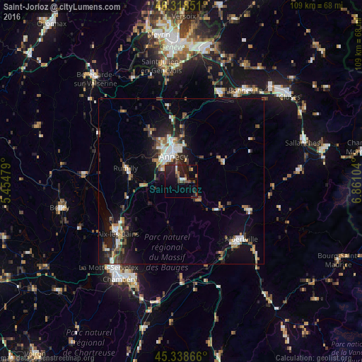
Analysis of Saint-Jorioz night lights 2016
Square area 10x10 km:
 0.89%
0.89%90-99
0.89%80-89
1.49%70-79
1.93%60-69
0.74%50-59
2.98%40-49
3.42%30-39
3.42%20-29
8.78%10-19
20.39%0-9
55.06%Square area 50x50 km:
1.13%90-99
1.62%80-89
0.76%70-79
0.86%60-69
1.14%50-59
1.29%40-49
1.38%30-39
1.39%20-29
3.19%10-19
7.46%0-9
79.78%Clear (daylight) street map image can be seen on geolist.org.
Map coordinates:
46° 19' 6.6" North, 5° 27' 17.2" East
45° 49' 50.7" North, 6° 9' 28.5" East
45° 20' 19.2" North, 6° 51' 39.7" East
Some cities around Saint-Jorioz sort by population:
• Annecy
9 km =5.6 mi,  343°
343°
• Annecy-le-Vieux
10 km =6.2 mi,  353°
353°
• Cran-Gevrier
8.9 km =5.5 mi,  329°
329°
• Seynod
8.1 km =5 mi,  318°
318°
• Meythet
10.9 km =6.8 mi, 333°
• Faverges
13.6 km =8.5 mi,  130°
130°
• Poisy
12.5 km =7.8 mi, 324°
• Thônes
14.2 km =8.8 mi,  66°
66°
2979175 (p: 5,571)
Sources (retrieved 2019-11-25):
» Earth at Night: Flat Maps 2012, 2016