Laukaa night lights from space
Night Light of Laukaa (Central Finland) from space (Finland) Src. Average luminocity for 10x10km area is 37.5978% and for 50x50km: 14.494%.
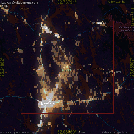
Analysis of Laukaa night lights 2016
Square area 10x10 km:
 0.3%
0.3%90-99
0.1%80-89
0.1%70-79
6.13%60-69
15.02%50-59
19.17%40-49
11.17%30-39
1.68%20-29
13.14%10-19
22.83%0-9
10.38%Square area 50x50 km:
1.53%90-99
1.58%80-89
0.88%70-79
1.8%60-69
2.6%50-59
3.9%40-49
3.29%30-39
2.72%20-29
3.16%10-19
9.09%0-9
69.46%Clear (daylight) street map image can be seen on geolist.org.
Map coordinates:
62° 44' 16.5" North, 25° 14' 55.8" East
62° 24' 50.7" North, 25° 57' 7" East
62° 5' 12.1" North, 26° 39' 18.3" East
Some cities around Laukaa sort by population:
• Jyväskylä
22.6 km =14 mi,  211°
211°
• Äänekoski
23.5 km =14.6 mi,  331°
331°
• Saarijärvi
48.2 km =30 mi,  312°
312°
• Muurame
34.5 km =21.4 mi, 205°
• Kangasniemi
59.1 km =36.7 mi,  142°
142°
• Suolahti
17.4 km =10.8 mi,  343°
343°
• Hankasalmi
25 km =15.5 mi,  97°
97°
• Korpilahti
48.9 km =30.4 mi, 205°
648738 (p: 17,093)
Sources (retrieved 2019-11-25):
» Earth at Night: Flat Maps 2012, 2016