Äänekoski night lights from space
Night Light of Äänekoski (Central Finland) from space (Finland) Src. Average luminocity for 10x10km area is 28.3623% and for 50x50km: 6.3162%.
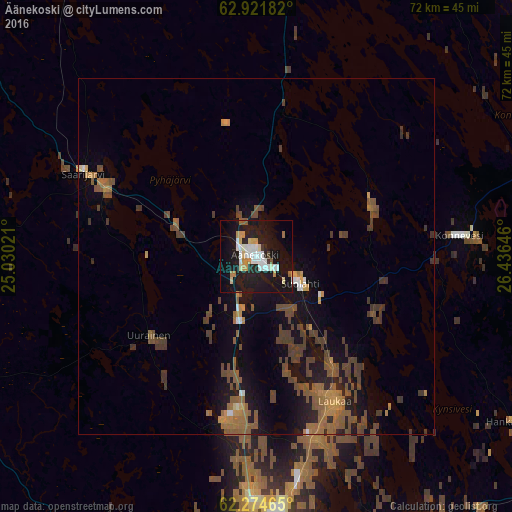
Analysis of Äänekoski night lights 2016
Square area 10x10 km:
 5.69%
5.69%90-99
6.31%80-89
2.48%70-79
4.66%60-69
1.14%50-59
1.35%40-49
0.52%30-39
0.83%20-29
6.94%10-19
43.69%0-9
26.4%Square area 50x50 km:
0.35%90-99
0.38%80-89
0.21%70-79
0.9%60-69
1.16%50-59
1.77%40-49
2.1%30-39
1.24%20-29
0.83%10-19
5.73%0-9
85.33%Clear (daylight) street map image can be seen on geolist.org.
Map coordinates:
62° 55' 18.6" North, 25° 1' 48.8" East
62° 36' 0" North, 25° 43' 60" East
62° 16' 28.7" North, 26° 26' 11.3" East
Some cities around Äänekoski sort by population:
• Jyväskylä
39.9 km =24.8 mi,  180°
180°
• Laukaa
23.5 km =14.6 mi,  151°
151°
• Keuruu
64.8 km =40.3 mi,  235°
235°
• Saarijärvi
27.1 km =16.8 mi,  295°
295°
• Muurame
52 km =32.3 mi, 183°
• Viitasaari
52.3 km =32.5 mi,  7°
7°
• Suolahti
7.3 km =4.5 mi,  122°
122°
• Hankasalmi
43.3 km =26.9 mi, 123°
662095 (p: 13,406)
Sources (retrieved 2019-11-25):
» Earth at Night: Flat Maps 2012, 2016