Kittilä night lights from space
Night Light of Kittilä (Lapland) from space (Finland) Src. Average luminocity for 10x10km area is 5.931% and for 50x50km: 0.5023%.
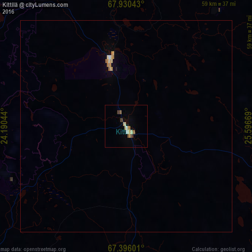
Analysis of Kittilä night lights 2016
Square area 10x10 km:
 0%
0%90-99
1.46%80-89
0.97%70-79
0.49%60-69
1.38%50-59
0.89%40-49
1.06%30-39
0.57%20-29
0%10-19
0%0-9
93.18%Square area 50x50 km:
0.01%90-99
0.1%80-89
0.1%70-79
0.08%60-69
0.11%50-59
0.04%40-49
0.04%30-39
0.02%20-29
0.01%10-19
0.02%0-9
99.46%Clear (daylight) street map image can be seen on geolist.org.
Map coordinates:
67° 55' 49.5" North, 24° 11' 25.6" East
67° 39' 53.1" North, 24° 53' 36.8" East
67° 23' 45.6" North, 25° 35' 48.1" East
Some cities around Kittilä sort by population:
• Rovaniemi
134.3 km =83.5 mi,  164°
164°
• Gällivare, SE
190.5 km =118.4 mi,  251°
251°
• Sodankylä
77.6 km =48.2 mi,  110°
110°
• Kemijärvi
152.2 km =94.6 mi,  134°
134°
• Inari
163.6 km =101.7 mi,  32°
32°
• Pyhäjärvi
119.4 km =74.2 mi,  123°
123°
• Malmberget, SE
188.9 km =117.4 mi, 253°
• Ylitornio
159.7 km =99.2 mi,  199°
199°
652590 (p: 5,713)
Sources (retrieved 2019-11-25):
» Earth at Night: Flat Maps 2012, 2016