Vilamarxant night lights from space
Night Light of Vilamarxant (Valencia) from space (Spain) Src. Average luminocity for 10x10km area is 23.8198% and for 50x50km: 23.3457%.
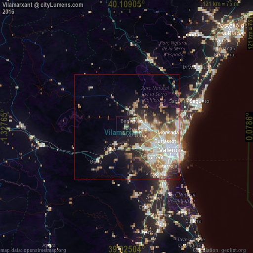
Analysis of Vilamarxant night lights 2016
Square area 10x10 km:
 1.79%
1.79%90-99
2.44%80-89
3.73%70-79
2.27%60-69
3.25%50-59
0.97%40-49
4.55%30-39
5.03%20-29
14.94%10-19
24.68%0-9
36.36%Square area 50x50 km:
4.99%90-99
4.76%80-89
2.43%70-79
2.96%60-69
3.74%50-59
2.98%40-49
2.59%30-39
3.01%20-29
5.11%10-19
8.68%0-9
58.76%Clear (daylight) street map image can be seen on geolist.org.
Map coordinates:
40° 6' 32.6" North, 1° 19' 39.5" West
39° 34' 9" North, 0° 37' 28.3" West
39° 1' 30.1" North, 0° 4' 43" East
Some cities around Vilamarxant sort by population:
• Llíria
7 km =4.3 mi,  18°
18°
• Bétera
14.2 km =8.8 mi,  80°
80°
• Ribarroja del Turia
5.3 km =3.3 mi,  119°
119°
• La Pobla de Vallbona
6.8 km =4.2 mi,  62°
62°
• L'Eliana
7.8 km =4.8 mi,  92°
92°
• Chiva
13.9 km =8.6 mi,  214°
214°
• Benaguasil
4.9 km =3 mi,  45°
45°
• Cheste
10.8 km =6.7 mi, 207°
2509576 (p: 6,730)
Sources (retrieved 2019-11-25):
» Earth at Night: Flat Maps 2012, 2016