Cheste night lights from space
Night Light of Cheste (Valencia) from space (Spain) Src. Average luminocity for 10x10km area is 24.8718% and for 50x50km: 20.8999%.
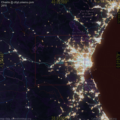
Analysis of Cheste night lights 2016
Square area 10x10 km:
 1.46%
1.46%90-99
3.9%80-89
5.36%70-79
3.57%60-69
2.6%50-59
2.27%40-49
0%30-39
3.25%20-29
4.38%10-19
45.62%0-9
27.6%Square area 50x50 km:
3.72%90-99
4.02%80-89
2.43%70-79
2.79%60-69
3.29%50-59
2.86%40-49
2.33%30-39
2.99%20-29
5.35%10-19
8.79%0-9
61.42%Clear (daylight) street map image can be seen on geolist.org.
Map coordinates:
40° 1' 26" North, 1° 23' 11.3" West
39° 28' 60" North, 0° 40' 60" West
38° 56' 18.7" North, 0° 1' 11.2" East
Some cities around Cheste sort by population:
• Ribarroja del Turia
11.9 km =7.4 mi,  54°
54°
• La Pobla de Vallbona
16.8 km =10.4 mi,  40°
40°
• L'Eliana
15.9 km =9.9 mi, 54°
• Chiva
3.4 km =2.1 mi,  237°
237°
• Benaguasil
15.6 km =9.7 mi,  33°
33°
• Buñol
11.3 km =7 mi,  229°
229°
• Vilamarxant
10.8 km =6.7 mi, 27°
• Turís
11.2 km =7 mi,  187°
187°
2519522 (p: 7,255)
Sources (retrieved 2019-11-25):
» Earth at Night: Flat Maps 2012, 2016