Tarifa night lights from space
Night Light of Tarifa (Andalusia) from space (Spain) Src. Average luminocity for 10x10km area is 7.2527% and for 50x50km: 11.241%.
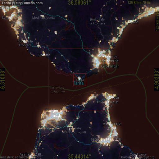
Analysis of Tarifa night lights 2016
Square area 10x10 km:
 1.47%
1.47%90-99
2.2%80-89
0%70-79
0%60-69
1.47%50-59
0.73%40-49
1.47%30-39
0.73%20-29
0%10-19
0%0-9
91.94%Square area 50x50 km:
1.95%90-99
1.88%80-89
1.22%70-79
1.12%60-69
1.71%50-59
1.1%40-49
1.32%30-39
1.81%20-29
3.83%10-19
7.27%0-9
76.79%Clear (daylight) street map image can be seen on geolist.org.
Map coordinates:
36° 34' 50.2" North, 6° 18' 36.3" West
36° 0' 50.1" North, 5° 36' 25" West
35° 26' 35.3" North, 4° 54' 13.8" West
Some cities around Tarifa sort by population:
• Tangier, MA
32.5 km =20.2 mi,  212°
212°
• Algeciras
19.3 km =12 mi,  46°
46°
• Ceuta
29.3 km =18.2 mi,  118°
118°
• La Línea de la Concepción
28.9 km =18 mi, 53°
• Fnidek, MA
29 km =18 mi,  129°
129°
• San Roque
29.6 km =18.4 mi,  42°
42°
• Gibraltar, GI
27.1 km =16.8 mi,  57°
57°
• Los Barrios
21.6 km =13.4 mi,  28°
28°
2510599 (p: 17,793)
Sources (retrieved 2019-11-25):
» Earth at Night: Flat Maps 2012, 2016