Segorbe night lights from space
Night Light of Segorbe (Valencia) from space (Spain) Src. Average luminocity for 10x10km area is 17.9728% and for 50x50km: 9.4493%.
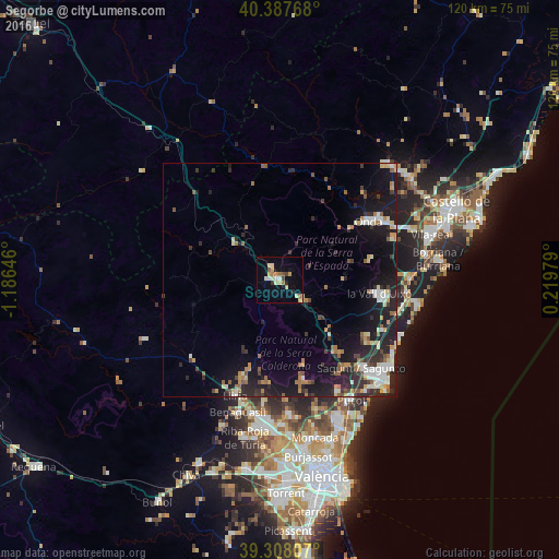
Analysis of Segorbe night lights 2016
Square area 10x10 km:
 1.53%
1.53%90-99
2.21%80-89
4.25%70-79
3.4%60-69
2.89%50-59
1.02%40-49
1.53%30-39
0.85%20-29
1.36%10-19
5.78%0-9
75.17%Square area 50x50 km:
1.16%90-99
1.39%80-89
0.96%70-79
1.05%60-69
1.3%50-59
1.1%40-49
0.88%30-39
1.38%20-29
3.28%10-19
8.91%0-9
78.59%Clear (daylight) street map image can be seen on geolist.org.
Map coordinates:
40° 23' 15.6" North, 1° 11' 11.3" West
39° 51' 0" North, 0° 28' 60" West
39° 18' 29.1" North, 0° 13' 11.2" East
Some cities around Segorbe sort by population:
• Sagunto
26.2 km =16.3 mi,  135°
135°
• Onda
22.9 km =14.2 mi,  56°
56°
• Llíria
26.5 km =16.5 mi,  201°
201°
• Bétera
28.8 km =17.9 mi,  176°
176°
• La Pobla de Vallbona
28.7 km =17.8 mi,  192°
192°
• Nules
27.9 km =17.3 mi,  89°
89°
• Betxí
25.9 km =16.1 mi,  69°
69°
• Almenara
25.3 km =15.7 mi,  116°
116°
2510972 (p: 8,371)
Sources (retrieved 2019-11-25):
» Earth at Night: Flat Maps 2012, 2016