Pinoso night lights from space
Night Light of Pinoso (Valencia) from space (Spain) Src. Average luminocity for 10x10km area is 8.3815% and for 50x50km: 8.3854%.
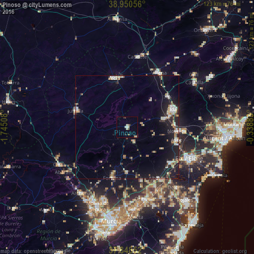
Analysis of Pinoso night lights 2016
Square area 10x10 km:
100  0.32%
0.32%
90-99 1.46%
80-89 2.44%
70-79 0.97%
60-69 0.65%
50-59 0.16%
40-49 0.65%
30-39 1.62%
20-29 1.3%
10-19 0.16%
0-9 90.26%
0.32%90-99
1.46%80-89
2.44%70-79
0.97%60-69
0.65%50-59
0.16%40-49
0.65%30-39
1.62%20-29
1.3%10-19
0.16%0-9
90.26%Square area 50x50 km:
100 0.85%
90-99 1.44%
80-89 1.12%
70-79 0.84%
60-69 0.89%
50-59 0.7%
40-49 0.82%
30-39 1.02%
20-29 2.39%
10-19 7.46%
0-9 82.47%
0.85%90-99
1.44%80-89
1.12%70-79
0.84%60-69
0.89%50-59
0.7%40-49
0.82%30-39
1.02%20-29
2.39%10-19
7.46%0-9
82.47%Clear (daylight) street map image can be seen on geolist.org.
Map coordinates:
38° 57' 2" North, 1° 44' 42.3" West
38° 24' 5.9" North, 1° 2' 31.1" West
37° 50' 54.7" North, 0° 20' 19.8" West
Some cities around Pinoso sort by population:
• Elda
23.4 km =14.5 mi,  68°
68°
• Yecla
24.4 km =15.2 mi,  344°
344°
• Novelda
24 km =14.9 mi,  94°
94°
• Aspe
24.8 km =15.4 mi,  104°
104°
• Monóvar
18 km =11.2 mi,  76°
76°
• Sax
24.7 km =15.3 mi,  52°
52°
• Fortuna
25.6 km =15.9 mi,  196°
196°
• Abanilla
21.8 km =13.5 mi,  179°
179°
2512510 (p: 7,090)
Sources (retrieved 2019-11-25):
» Earth at Night: Flat Maps 2012, 2016