Abanilla night lights from space
Night Light of Abanilla (Murcia) from space (Spain) Src. Average luminocity for 10x10km area is 11.9864% and for 50x50km: 23.9782%.
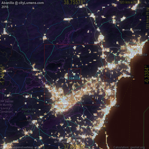
Analysis of Abanilla night lights 2016
Square area 10x10 km:
 0.34%
0.34%90-99
1.36%80-89
1.19%70-79
1.53%60-69
0.51%50-59
0.51%40-49
1.19%30-39
2.21%20-29
1.36%10-19
13.78%0-9
76.02%Square area 50x50 km:
2.32%90-99
3.7%80-89
3.22%70-79
3.77%60-69
4.68%50-59
3.42%40-49
3.51%30-39
3.58%20-29
7.44%10-19
14.17%0-9
50.19%Clear (daylight) street map image can be seen on geolist.org.
Map coordinates:
38° 45' 20.8" North, 1° 44' 40.7" West
38° 12' 19.3" North, 1° 2' 29.5" West
37° 39' 2.7" North, 0° 20' 18.2" West
Some cities around Abanilla sort by population:
• Orihuela
15.9 km =9.9 mi,  147°
147°
• Callosa de Segura
16.8 km =10.4 mi,  122°
122°
• Santomera
16 km =9.9 mi,  182°
182°
• Albatera
15.2 km =9.4 mi,  101°
101°
• Beniel
18 km =11.2 mi,  169°
169°
• Fortuna
7.8 km =4.8 mi,  250°
250°
• Redován
15.2 km =9.4 mi,  130°
130°
• Cox
15.2 km =9.4 mi, 117°
2522505 (p: 6,079)
Sources (retrieved 2019-11-25):
» Earth at Night: Flat Maps 2012, 2016