Fortuna night lights from space
Night Light of Fortuna (Murcia) from space (Spain) Src. Average luminocity for 10x10km area is 17.5493% and for 50x50km: 21.6541%.
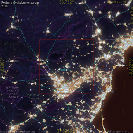
Analysis of Fortuna night lights 2016
Square area 10x10 km:
 0.68%
0.68%90-99
1.87%80-89
2.55%70-79
3.4%60-69
1.87%50-59
1.7%40-49
0.17%30-39
2.72%20-29
2.38%10-19
26.02%0-9
56.63%Square area 50x50 km:
2.35%90-99
3.55%80-89
2.89%70-79
3.75%60-69
4.38%50-59
2.99%40-49
2.95%30-39
2.74%20-29
5.57%10-19
10.04%0-9
58.8%Clear (daylight) street map image can be seen on geolist.org.
Map coordinates:
38° 43' 55.2" North, 1° 49' 44.5" West
38° 10' 53" North, 1° 7' 33.2" West
37° 37' 35.8" North, 0° 25' 22" West
Some cities around Fortuna sort by population:
• Molina de Segura
15.8 km =9.8 mi,  206°
206°
• Archena
16.9 km =10.5 mi,  244°
244°
• Santomera
14.9 km =9.3 mi,  153°
153°
• Ceuti
17.3 km =10.7 mi,  228°
228°
• Alguazas
17.9 km =11.1 mi,  217°
217°
• Esparragal
16.9 km =10.5 mi,  167°
167°
• Lorquí
15.5 km =9.6 mi, 224°
• Abanilla
7.8 km =4.8 mi,  70°
70°
2517679 (p: 7,943)
Sources (retrieved 2019-11-25):
» Earth at Night: Flat Maps 2012, 2016