Albal night lights from space
Night Light of Albal (Valencia) from space (Spain) Src. Average luminocity for 10x10km area is 76.4269% and for 50x50km: 29.8236%.
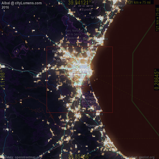
Analysis of Albal night lights 2016
Square area 10x10 km:
100  21.26%
90-99 23.3%
80-89 8.5%
70-79 8.67%
60-69 14.97%
50-59 7.99%
40-49 5.78%
30-39 3.57%
20-29 4.76%
10-19 1.19%
0-9 0%
21.26%90-99
23.3%80-89
8.5%70-79
8.67%60-69
14.97%50-59
7.99%40-49
5.78%30-39
3.57%20-29
4.76%10-19
1.19%0-9
0%Square area 50x50 km:
100 5.97%
90-99 5.98%
80-89 3.37%
70-79 3.71%
60-69 4.07%
50-59 3.51%
40-49 3.36%
30-39 4.27%
20-29 8.71%
10-19 13.93%
0-9 43.13%
5.97%90-99
5.98%80-89
3.37%70-79
3.71%60-69
4.07%50-59
3.51%40-49
3.36%30-39
4.27%20-29
8.71%10-19
13.93%0-9
43.13%Clear (daylight) street map image can be seen on geolist.org.
Map coordinates:
39° 56' 28.4" North, 1° 7' 11.3" West
39° 24' 0" North, 0° 25' 0" West
38° 51' 16.4" North, 0° 17' 11.2" East
Some cities around Albal sort by population:
• Catarroja
1.4 km =0.9 mi,  90°
90°
• Paiporta
3.1 km =1.9 mi,  358°
358°
• Alfafar
3.4 km =2.1 mi,  57°
57°
• Silla
4.2 km =2.6 mi,  174°
174°
• Benetússer
3 km =1.9 mi,  34°
34°
• Picanya
4 km =2.5 mi,  338°
338°
• Sedaví
4.7 km =2.9 mi,  37°
37°
• Alcàsser
4.3 km =2.7 mi,  213°
213°
2522250 (p: 15,443)
Sources (retrieved 2019-11-25):
» Earth at Night: Flat Maps 2012, 2016