Pasaia night lights from space
Night Light of Pasaia (Basque Country) from space (Spain) Src. Average luminocity for 10x10km area is 51.303% and for 50x50km: 9.6978%.
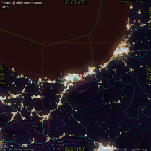
Analysis of Pasaia night lights 2016
Square area 10x10 km:
 16.52%
90-99
13.33%80-89
4.09%70-79
1.36%60-69
4.09%50-59
6.82%40-49
2.73%30-39
4.09%20-29
20.45%10-19
24.39%0-9
2.12%Square area 50x50 km:
1.94%90-99
1.82%80-89
0.64%70-79
0.58%60-69
0.89%50-59
1.56%40-49
0.77%30-39
0.98%20-29
3.22%10-19
8.53%0-9
79.06%Clear (daylight) street map image can be seen on geolist.org.
Map coordinates:
43° 50' 4.7" North, 2° 37' 48.7" West
43° 19' 31.1" North, 1° 55' 37.5" West
42° 48' 41.9" North, 1° 13' 26.2" West
Some cities around Pasaia sort by population:
• Donostia / San Sebastián
4.1 km =2.5 mi,  250°
250°
• Irun
11.2 km =7 mi,  82°
82°
• Errenteria
2.5 km =1.6 mi,  126°
126°
• Hernani
7.7 km =4.8 mi,  211°
211°
• Oria
10.7 km =6.6 mi,  223°
223°
• Lasarte
10 km =6.2 mi,  230°
230°
• Lezo
2.4 km =1.5 mi,  100°
100°
• Urnieta
10.1 km =6.3 mi, 210°
6693088 (p: 15,990)
Sources (retrieved 2019-11-25):
» Earth at Night: Flat Maps 2012, 2016