Errenteria night lights from space
Night Light of Errenteria (Basque Country) from space (Spain) Src. Average luminocity for 10x10km area is 48.3879% and for 50x50km: 9.8843%.
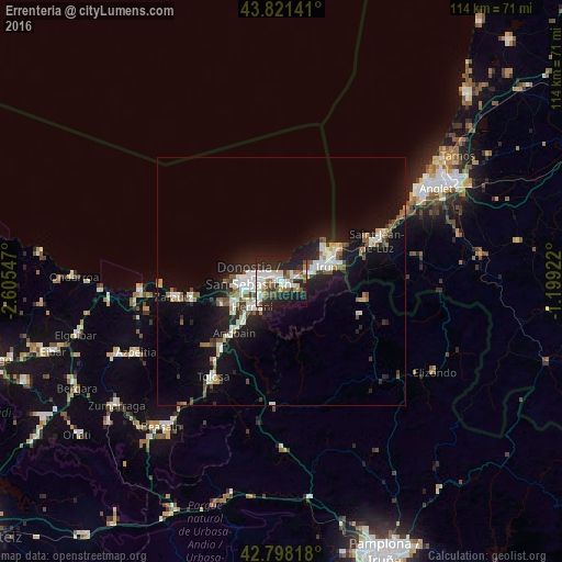

Analysis of Errenteria night lights 2016
Square area 10x10 km:
 12.58%
90-99
10.15%80-89
5.15%70-79
1.36%60-69
5.91%50-59
8.18%40-49
3.18%30-39
4.7%20-29
24.55%10-19
22.12%0-9
2.12%Square area 50x50 km:
1.95%90-99
1.83%80-89
0.65%70-79
0.58%60-69
0.89%50-59
1.65%40-49
0.85%30-39
1%20-29
3.2%10-19
8.89%0-9
78.5%Clear (daylight) street map image can be seen on geolist.org.
Map coordinates:
43° 49' 17.1" North, 2° 36' 19.7" West
43° 18' 43" North, 1° 54' 8.4" West
42° 47' 53.4" North, 1° 11' 57.2" West
Some cities around Errenteria sort by population:
• Donostia / San Sebastián
5.9 km =3.7 mi,  270°
270°
• Irun
9.6 km =6 mi,  71°
71°
• Hernani
7.8 km =4.8 mi,  229°
229°
• Lasarte
10.8 km =6.7 mi,  243°
243°
• Hondarribia
10.6 km =6.6 mi,  53°
53°
• Pasaia
2.5 km =1.6 mi,  306°
306°
• Lezo
1.1 km =0.7 mi,  20°
20°
• Urnieta
10.2 km =6.3 mi,  224°
224°
3112011 (p: 38,767)
Sources (retrieved 2019-11-25):
» Earth at Night: Flat Maps 2012, 2016