Palafrugell night lights from space
Night Light of Palafrugell (Catalonia) from space (Spain) Src. Average luminocity for 10x10km area is 30.5381% and for 50x50km: 8.0279%.
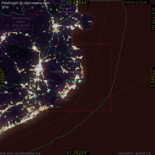
Analysis of Palafrugell night lights 2016
Square area 10x10 km:
 2.38%
2.38%90-99
3.33%80-89
5.4%70-79
3.33%60-69
3.02%50-59
3.97%40-49
5.4%30-39
4.6%20-29
9.21%10-19
44.92%0-9
14.44%Square area 50x50 km:
0.83%90-99
1.14%80-89
0.99%70-79
0.85%60-69
0.87%50-59
0.98%40-49
0.96%30-39
0.99%20-29
1.7%10-19
8.3%0-9
82.39%Clear (daylight) street map image can be seen on geolist.org.
Map coordinates:
42° 26' 18.4" North, 2° 27' 35.9" East
41° 55' 2.6" North, 3° 9' 47.2" East
41° 23' 31.3" North, 3° 51' 58.4" East
Some cities around Palafrugell sort by population:
• Sant Feliu de Guíxols
18.4 km =11.4 mi,  215°
215°
• Palamós
8.2 km =5.1 mi,  200°
200°
• Torroella de Montgrí
14.2 km =8.8 mi,  347°
347°
• Calonge
9.5 km =5.9 mi,  226°
226°
• la Bisbal d'Empordà
10 km =6.2 mi,  291°
291°
• Castell-Platja d'Aro
13.6 km =8.5 mi, 215°
• l'Escala
23.3 km =14.5 mi, 353°
• Santa Cristina d'Aro
17.5 km =10.9 mi, 230°
3114567 (p: 22,365)
Sources (retrieved 2019-11-25):
» Earth at Night: Flat Maps 2012, 2016