Ordes night lights from space
Night Light of Ordes (Galicia) from space (Spain) Src. Average luminocity for 10x10km area is 5.9222% and for 50x50km: 11.506%.
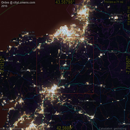
Analysis of Ordes night lights 2016
Square area 10x10 km:
 0.79%
0.79%90-99
0.48%80-89
0.63%70-79
0.63%60-69
0.32%50-59
0.63%40-49
1.43%30-39
1.75%20-29
1.43%10-19
0.48%0-9
91.43%Square area 50x50 km:
0.99%90-99
1.57%80-89
0.98%70-79
1.17%60-69
2.08%50-59
2%40-49
2.44%30-39
2.39%20-29
4.02%10-19
6.68%0-9
75.69%Clear (daylight) street map image can be seen on geolist.org.
Map coordinates:
43° 35' 16.7" North, 9° 6' 43.6" West
43° 4' 35.5" North, 8° 24' 32.4" West
42° 33' 38.9" North, 7° 42' 21.1" West
Some cities around Ordes sort by population:
• Santiago de Compostela
24.5 km =15.2 mi,  207°
207°
• Culleredo
23.6 km =14.7 mi,  4°
4°
• Cambre
24.7 km =15.3 mi,  11°
11°
• Laracha
24.3 km =15.1 mi,  324°
324°
• Arzúa
26.4 km =16.4 mi,  127°
127°
• Oroso
10.6 km =6.6 mi,  190°
190°
• Abegondo
18.6 km =11.6 mi,  33°
33°
• Carral
17.5 km =10.9 mi, 14°
3114992 (p: 12,757)
Sources (retrieved 2019-11-25):
» Earth at Night: Flat Maps 2012, 2016