Mondariz night lights from space
Night Light of Mondariz (Galicia) from space (Spain) Src. Average luminocity for 10x10km area is 6.8045% and for 50x50km: 23.5598%.
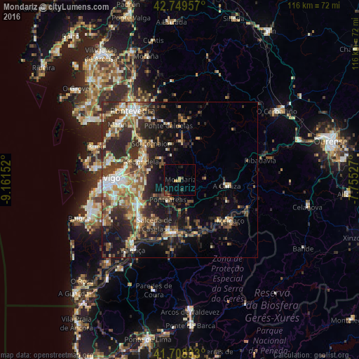
Analysis of Mondariz night lights 2016
Square area 10x10 km:
 0%
0%90-99
0%80-89
0.91%70-79
1.36%60-69
0.45%50-59
0%40-49
2.12%30-39
2.12%20-29
1.21%10-19
1.97%0-9
89.85%Square area 50x50 km:
2.26%90-99
4.19%80-89
2.78%70-79
2.95%60-69
3.49%50-59
3.69%40-49
3.87%30-39
4.72%20-29
10.12%10-19
11.6%0-9
50.33%Clear (daylight) street map image can be seen on geolist.org.
Map coordinates:
42° 44' 58.5" North, 9° 9' 41.5" West
42° 13' 52" North, 8° 27' 30.2" West
41° 42' 30" North, 7° 45' 19" West
Some cities around Mondariz sort by population:
• Vigo
21.8 km =13.5 mi,  270°
270°
• Redondela
13.7 km =8.5 mi,  295°
295°
• Ponteareas
7.3 km =4.5 mi,  210°
210°
• Monção, PT
17 km =10.6 mi,  186°
186°
• Moaña
23.7 km =14.7 mi,  282°
282°
• Porriño
15.4 km =9.6 mi,  239°
239°
• Tui
25.6 km =15.9 mi,  216°
216°
• Salvatierra de Miño
16.8 km =10.4 mi, 191°
3116514 (p: 5,259)
Sources (retrieved 2019-11-25):
» Earth at Night: Flat Maps 2012, 2016