Monção night lights from space
Night Light of Monção (Viana do Castelo) from space (Portugal) Src. Average luminocity for 10x10km area is 31.3682% and for 50x50km: 19.0093%.
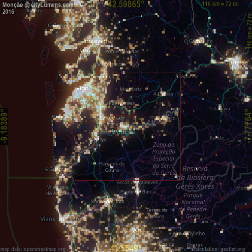
Analysis of Monção night lights 2016
Square area 10x10 km:
 1.36%
1.36%90-99
3.03%80-89
3.18%70-79
3.18%60-69
5.15%50-59
4.7%40-49
6.52%30-39
8.48%20-29
13.03%10-19
46.82%0-9
4.55%Square area 50x50 km:
1.85%90-99
3.47%80-89
2.14%70-79
2.28%60-69
2.82%50-59
3.07%40-49
3.55%30-39
3.6%20-29
6.06%10-19
10.7%0-9
60.47%Clear (daylight) street map image can be seen on geolist.org.
Map coordinates:
42° 35' 55.1" North, 9° 11' 2" West
42° 4' 44.1" North, 8° 28' 50.7" West
41° 33' 17.6" North, 7° 46' 39.5" West
Some cities around Monção sort by population:
• Ponteareas, ES
10.8 km =6.7 mi,  349°
349°
• Porriño, ES
14.7 km =9.1 mi,  308°
308°
• Tui, ES
14 km =8.7 mi,  255°
255°
• Valenza
14.1 km =8.8 mi,  244°
244°
• Gondomar, ES
22.5 km =14 mi,  279°
279°
• Salvatierra de Miño, ES
1.7 km =1.1 mi,  287°
287°
• Mozelos
24.5 km =15.2 mi,  163°
163°
• Mondariz, ES
17 km =10.6 mi,  6°
6°
2737523 (p: 19,738)
Sources (retrieved 2019-11-25):
» Earth at Night: Flat Maps 2012, 2016